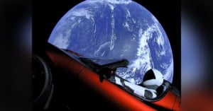
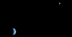
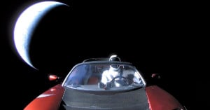
You know those digital photos you’ve archived by burning onto DVDs and sticking under your bed? You’ll be lucky if the files are still readable by the end of your life. Photographer Trevor Paglen wants to archive photos for a much longer time… and by “much longer”, we mean billions of years. He’s not just doing this for himself, either, but for all of humanity. Read more…
We’re shared a couple of “stacked star trail” time-lapse videos over the past few months (see here and here), but those videos comprised nighttime photographs taken from the ground. Photographer Christoph Malin recently decided to try his hand at the technique, but instead of using his own earthbound photographs, he used NASA photographs shot from the International Space Station. The resulting video, shown above, features the stars drawing trails across the “sky” while the Earth creates light streaks down below. Read more…
Fractal-like patterns are found widely in nature, “in phenomena including clouds, river networks, geologic fault lines, mountains, coastlines, animal coloration, snow flakes, crystals blood vessel branching, ocean waves and many others.” The fact that it appears on a large scale in geographical formations means that many of these beautiful patterns can be captured as photographs from space.
Planetary conjunctions are beautiful to photograph from Earth, but send a camera to another planet in the Solar System, and you can shoot a planetary conjunction photograph containing Earth!
Back on May 8th, 2003, the Mars Orbiter Camera on the Mars Global Surveyor had the rare opportunity to photograph both the Earth and Jupiter in the same region of space. It was the first planetary conjunction observed from another planet, with the Earth 86 million miles away and Jupiter 600 million miles away. The resulting image (shown above right), contains both planets, along with some of the moons. Read more…
The scary face in this image is actually inundated patches of shallow Lake Eyre (pronounced “air”) in the desert country of northern South Australia. An ephemeral feature of this flat, parched landscape, Lake Eyre is Australia’s largest lake when it’s full. However in the last 150 years, it has filled completely only three times.
Satellite photographs of Earth are often abstract and artsy, filled with strange colors, shapes, and textures. Some resemble the paintings of old masters, while others look like microscopic slides studied in biology classes. NASA’s LandSat has snapped images from space for 40 years now, with many of the images going into a special collection by the U.S. Geological Survey called “Earth as Art“. NASA recently decided to run a photo beauty contest to find out which of the satellite images in its collection are the most artistic.
Over 14,000 people ended up voting on the collection of 120+ images. The image above came in at number 5. It’s titled “Lake Eyre Landsat 5 Acquired 8/5/2006″. Read more…
Yesterday marked the 40th anniversary of Landsat, the longest-running program focused on acquiring satellite photos of Earth. The Landsat satellite snaps one completely photo of the Earth’s surface every 16 days, and the petabytes of photos collected over the years have given scientists a view into how our planet’s surface has changed over time, whether by natural or human-caused means. Google is currently working to make the photos easily enjoyable by the general public by transforming them into time-lapse videos. Read more…
Photographer Knate Myers of Albuquerque, New Mexico created this awe-inspiring time-lapse video using long-exposure night shots captured by astronauts on the International Space Station. This is one video you’ll have to watch in HD and at full screen.
We’ve seen ‘Blue Marble’ photos of Earth before, but this latest NASA photo is different: it’s the first photo of its kind shot from above our planet’s North Pole. The photo is a composite of images captured by a satellite as it passed over the North Pole 15 times at an altitude of 512 miles.
It looks like not even space photography has managed to escape the pixel war, but in the case of the Russian Federal Space Agency’s Elektro-L weather satellite, we’re not complaining. The video you see above is a time lapse put together from 6 days worth of 121-megapixel images taken every 30 minutes by the satellite. The images themselves are not composites of several either, they are just incredibly detailed photos of the entire planet taken from some 22 thousand miles away.
They’re so detailed, in fact, that the resolution comes out to about 1 kilometer per pixel — or in laymen’s terms: this ain’t no camera phone. To add a little bit of color to the proceedings the images are also taken in 4 rather than just 3 wavelengths, yielding that orange color which is actually infrared imaging of vegetation. You can click here to see some higher resolution photos from the Elektro-L, or here if you want to see some photos of the satellite itself.