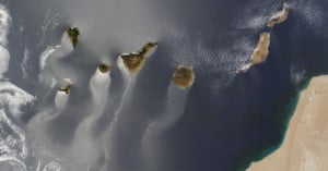
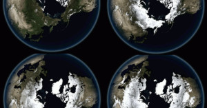
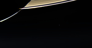
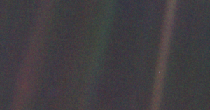
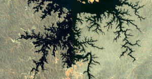
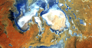
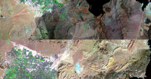
earth

Two Spectacular Photographs of a Volcanic Eruption as Seen from Space by Endeavour

In September and October of 1994, the space shuttle Endeavour was orbiting 115 nautical miles above Earth while the Kliuchevskoi Volcano was spewing ash and dust into the atmosphere at an alarming rate. Not in any position to do anything about it, the astronauts aboard the space shuttle did the only thing they could do... they took pictures.

NASA’s Iconic ‘Blue Marble’ Photo of Earth Turns 41 Years Old

Backlighting can be all moody and subtle, but you can seldom go wrong with full-on, straight-behind illumination. Especially if your subject is the planet on which your family, friends and all of humanity happens to reside.

That's what the trio of Apollo 17 astronauts -- and soon, the whole world -- discovered 41 years and two days ago today. Navigating towards the moon on Dec. 7, 1972,  the spacecraft had the sun behind it, providing a rare, fully illuminated view of the Earth.

This is What the Sky Would Look Like if the Moon Was at the Same Distance as the ISS

We've shown off some interesting videos/photo series in the past that highlight different fictional skylines. For instance, you can see what it would look like if each of our solar system's planets replaced the Moon, or if the Earth had rings like Saturn.

The video above shows another interesting scenario: this is what the sky would look like if the Moon was at the same distance from the Earth as the ISS.

Incredible Photos of The Moon Casting Its Shadow on Earth During a Solar Eclipse

Over the years, we've seen some pretty incredible eclipse photos, be they composites that'll blow your mind or time-lapses that'll capture your attention for minutes at a time.

What we haven't seen nearly as much of are solar eclipse photos taken from space. What exactly does it look like when you turn the cameras the other way and capture the Moon's shadow hitting the Earth?

Image of Earth Made Up of 1400 Photos of People Waving at the Cassini Spacecraft

On July 19th, the Cassini spacecraft that has been hovering around Saturn -- and sending back some stunning images we might add -- turned around to take a picture of its home planet as part of a larger mosaic of the Saturn system.

In honor of this occasion, NASA asked people to send in photos of them waving at Cassini as it took their picture from roughly 808 Million miles away (give or take). Over 1,400 photos were submitted, and have been combined into a beautiful collage of Earth.

Amazing Time-Lapse of Earth Captured by Spacecraft Leaving Our Planet

In August of 2005, one year after being launched into space, the NASA spacecraft MESSENGER performed a gravity assist swing-by of our little blue planet. As it drifted away from Earth on its way to Mercury, MESSENGER proceeded to capture hundreds of stunning photos, many of which have been compiled into this amazing time-lapse view of Earth.

Lightning Storms Photographed From High Above in Space

Hey aspiring storm chasers -- want to dramatically improve your lightning shots? Try getting an elevated view. Like about 400 miles up. That's the approximate orbital height above Earth of the International Space Station, which is producing an impressive library of images showing what lightning looks like from way above.

Cassini Snaps New Photographs Showing Earth Next to Saturn’s Rings

Were you smiling a lot Friday afternoon? Hope so, because that's when you and your 7 billion planetary neighbors got a rare portrait session from the Cassini spacecraft. Orbiting above Saturn almost a billion miles away, the craft turned its camera towards to Earth to capture some spectacular images of our planet foregrounded by Saturn's rings.

It was the first time in nine years that Cassini has been in orbit and taking scheduled photos of our planet, prompting NASA and friends to promote a "The Day That the Earth Smiled" event via social media.

Photographing Earth from the Cupola on the International Space Station

NASA's Image of the Day today is a photograph showing one of the best photo op spots to be found on the International Space Station: the Cupola module. The image (shown above) shows astronaut and flight engineer Chris Cassidy pointing a Nikon DSLR and 400mm lens out one of the Cupola's windows to photograph some location on Earth 250 miles below him.

$25 Space Camera: Raspberry Pi Camera Snaps Photos of Earth on a Balloon

Raspberry Pi's new Camera Module is starting to hit store shelves, and we're starting to see some interesting photo experiments being done with the simple programmable camera kit.

High altitude ballooning enthusiast Dave Akerman recently decided to send his $25 module up to the edges of space to snap photographs of Earth and beam images back during its flight.

Astronaut Chris Hadfield Explains How to Take Pictures of Earth from Space

Canadian astronaut Chris Hadfield has been serving as one of the International Space Station's resident photographers. Every day he posts beautiful photographs showing what our planet looks like from orbit to his Twitter account, @cmdr_hadfield.

Today the Canadian Space Agency released the video above, in which Hadfield takes the time to explain how to best photograph Earth's landscape from 400km (~250 miles) above the surface.

Underwater Volcano Photo Wins NASA’s March Madness-style Photo Tourney

March Madness 2013 came to a thrilling end yesterday with Louisville beating Michigan in the college men's basketball national championship game. Another (less publicized) tournament selected a winner as well: NASA's first ever photo tournament. No, it wasn't a contest in which photographers submit their best image. Instead, Earth 2013 was a tourney that pitted 32 of NASA's photos of Earth against each other in a March Madness-style tourney.

NASA Releases Beautiful Compilation of 2012 Satellite Imagery

Taking a cue from the music industry and those incessant Now That's What I Call Music! albums, NASA has released its own "best-of" compilation of the most compelling imagery its satellites collected this past year. A mixture of true color, computer models, visualizations, and time-lapses from the ISS, the video gives us yet another stunning view of our little blue planet.

The Pale Blue Dot: A Portrait of Earth Shot From 3.7 Billion Miles Away

Seeing as the Voyager-1 spacecraft has been in the news recently, here's the story of a very special photograph that it took 23 years ago known as "The Pale Blue Dot".

In 1990, 13 years after Voyager-1 left Earth on its mission to visit two of the gas giants and their moons of our solar system, Jupiter and Saturn, one last command was sent to the spacecraft as suggested by Carl Sagan who was then part of the Voyager-1's imaging team. That instruction was to turn back around and take one last photo of our solar system before continuing on its epic journey away from the Sun and the planets.

Astronauts on the ISS Use a ‘NightPod’ to Stabilize Their Low-Light Photos

Astronaut photographers on the International Space Station have been beaming quite a few photographs of Earth as of late, but have you ever wondered how they manage capture relatively sharp photographs of Earth's cities at night?

The speed at which the ISS hurtles around our planet is indeed a major challenge for low-light photography, and astronauts in the past have tried to overcome it by using high-speed film or by doing some manual tracking (which is very hit-and-miss). Luckily, space shooters nowadays have a new special tool up their sleeve: the NightPod.

A Time-Lapse Message From the ISS to All of Humankind

Photographs captured by astronauts on the International Space Station are in the public domain, so they're often remixed into gorgeous time-lapse videos. Italian filmmaker Giacomo Sardelli went a step beyond many of the ISS time-lapses we've seen by adding in more than just epic music: he included short audio messages recorded by the astronauts who worked in the space station.

Black Marble: NASA Releases Incredibly Detailed Photos of Earth at Night

You've probably heard of The Blue Marble, an iconic photo of Earth captured in 1972 from 28,000 miles away by astronauts on the Apollo 17 spacecraft. Well, NASA has just released a number of photographs titled "Black Marble." They offer the same perspective as the iconic photo, except these new images show what our planet looks like at night!

Photog Archiving 100 Images for Billions of Years by Sending Them to Space

You know those digital photos you've archived by burning onto DVDs and sticking under your bed? You'll be lucky if the files are still readable by the end of your life. Photographer Trevor Paglen wants to archive photos for a much longer time... and by "much longer", we mean billions of years. He's not just doing this for himself, either, but for all of humanity.

Stacked Star Trail Time-Lapse Created with Photos Shot from Space

We're shared a couple of "stacked star trail" time-lapse videos over the past few months (see here and here), but those videos comprised nighttime photographs taken from the ground. Photographer Christoph Malin recently decided to try his hand at the technique, but instead of using his own earthbound photographs, he used NASA photographs shot from the International Space Station. The resulting video, shown above, features the stars drawing trails across the "sky" while the Earth creates light streaks down below.

Beautiful Satellite Photos Showing Fractal Patterns on the Face of the Earth

Fractal-like patterns are found widely in nature, "in phenomena including clouds, river networks, geologic fault lines, mountains, coastlines, animal coloration, snow flakes, crystals blood vessel branching, ocean waves and many others." The fact that it appears on a large scale in geographical formations means that many of these beautiful patterns can be captured as photographs from space.

Paul Bourke, a professor at the University of Western Australia, has a webpage dedicated to Google Earth satellite photos that contain these patterns.

Earth and Jupiter Seen in a Single Photo Taken From Mars

Planetary conjunctions are beautiful to photograph from Earth, but send a camera to another planet in the Solar System, and you can shoot a planetary conjunction photograph containing Earth!

Back on May 8th, 2003, the Mars Orbiter Camera on the Mars Global Surveyor had the rare opportunity to photograph both the Earth and Jupiter in the same region of space. It was the first planetary conjunction observed from another planet, with the Earth 86 million miles away and Jupiter 600 million miles away. The resulting image (shown above right), contains both planets, along with some of the moons.

The 5 Most Artistic Satellite Photographs of Earth Captured by NASA

Satellite photographs of Earth are often abstract and artsy, filled with strange colors, shapes, and textures. Some resemble the paintings of old masters, while others look like microscopic slides studied in biology classes. NASA's LandSat has snapped images from space for 40 years now, with many of the images going into a special collection by the U.S. Geological Survey called "Earth as Art". NASA recently decided to run a photo beauty contest to find out which of the satellite images in its collection are the most artistic.

Over 14,000 people ended up voting on the collection of 120+ images. The image above came in at number 5. It's titled "Lake Eyre Landsat 5 Acquired 8/5/2006".

40 Years of Landsat: Time-Lapse Videos Show Changes to Earth’s Face

Yesterday marked the 40th anniversary of Landsat, the longest-running program focused on acquiring satellite photos of Earth. The Landsat satellite snaps one completely photo of the Earth's surface every 16 days, and the petabytes of photos collected over the years have given scientists a view into how our planet's surface has changed over time, whether by natural or human-caused means. Google is currently working to make the photos easily enjoyable by the general public by transforming them into time-lapse videos.

First Full Photo of Earth As Seen From Above the North Pole

We've seen 'Blue Marble' photos of Earth before, but this latest NASA photo is different: it's the first photo of its kind shot from above our planet's North Pole. The photo is a composite of images captured by a satellite as it passed over the North Pole 15 times at an altitude of 512 miles.

Satellite Photographs Showing the Rapid Spread of Humans Across the Earth

2008 marked the first time in history that more of Earth's population lived in cities rather than in the countryside, and by 2050 nearly 70% of the world's population will reside in large cities. A new series of satellite photographs captured decades apart by NASA's Landsat department and the U.S. Geological Survey offers a striking look at how human cities have spread across the face of the Earth in just a few short years. The image above shows Las Vegas in 1984 and in 2011.

Auroras, Meteors, and Photography from the International Space Station

Here's a fascinating video by NASA that explains what auroras are and what they look like from space. It's filled with beautiful photographs and time-lapse sequences captured by astronauts on the International Space Station. Astronaut photographer Don Pettit, who maintains a blog about his experiences, writes that taking pictures of Earth is harder than it looks.

Shoot, Share, and Explore Satellite Photos of Earth with Stratocam

If you've always wanted to be an astronaut photographer shooting images of Earth from a window of the International Space Station, Stratocam is an app for you. Created by Paul Rademacher, it allows you to snap your own photographs inside Google Maps' satellite view of our planet. You can also view and rate other people's photos, and browse the highest rated images from around the world.

How NASA Creates Those Beautiful Blue Marble Photos of Earth

After NASA published its latest jaw-dropping "Blue Marble" photograph of Earth last month, many of you wondered how "real" the image was. Here's NASA's explanation on how their images are created:

The Suomi NPP satellite is in a polar orbit around Earth at an altitude of 512 miles (about 824 kilometers), but the perspective of the new Eastern hemisphere 'Blue Marble' is from 7,918 miles (about 12,743 kilometers). NASA scientist Norman Kuring managed to 'step back' from Earth to get the big picture by combining data from six different orbits of the Suomi NPP satellite. Or putting it a different way, the satellite flew above this area of Earth six times over an eight hour time period. Norman took those six sets of data and combined them into one image.

So rather than being a composite of multiple images captured from the same perspective, they do in fact map images captured by the satellite onto a 3D sphere.