Google Maps Satellite Image Appears to Show US Prototype Underwater Drone
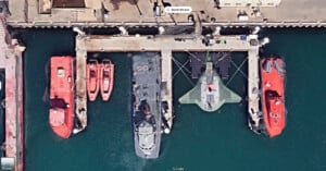
A Google Maps satellite image has picked up what is believed to be a prototype U.S. military underwater drone north of Los Angeles.
A Google Maps satellite image has picked up what is believed to be a prototype U.S. military underwater drone north of Los Angeles.
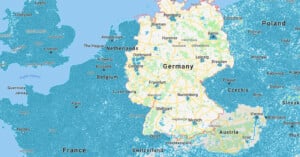
For residents and tourists alike, Google Maps Street View is an exceptionally useful navigational tool. However, not every country has welcomed Google's iconic Street View cars to their streets. One of these longtime holdouts, Germany, has only recently begun to change its tune after more than a decade of resistance. But why?

A photo location expert has made a tutorial explaining how to find the exact location of a photo with just a few clues.

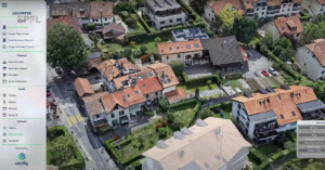
At the annual Google I/O keynote, Google announced numerous updates to Google Maps, including a new Immersive View for routes.
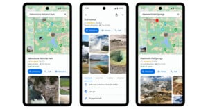
Ahead of summer, a popular time for people to visit the US's many national parks, Google is updating Google Maps with helpful new information to make it easier for people to plan outdoor adventures and navigate national parks.

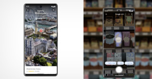
Google is making significant improvements to Maps, including a new artificial intelligence-powered (AI) "Immersive View" that is available for select major cities.
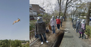
A coder has created a new website that explores the quirks and curiosities that Google Street View has to offer.
A company that creates interactive aerial images of living environments describes its product as "Google Earth on steroids."

A music video has been made entirely from Google Street View images that takes in locations from all around the world.
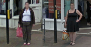
A British woman has been left "flabbergasted" after she was captured on Google Maps Street View standing in the exact same spot nine years apart.

Google has been developing a 3D Immersive View feature for Google Maps that will provide a bird's-eye view of notable landmarks. The new feature is being rolled out to mobile users, on both Android and iOS platforms, and includes 3D images of nearly 100 famous landmarks around the world.
Meta CEO Mark Zuckerberg has announced a new searchable map for Instagram where users can discover nearby local businesses.

A Google executive says that younger users are now increasingly turning to apps like Instagram and TikTok instead of Google Search or Maps to discover new places or search for information.

To celebrate Google Street View's 15th birthday, the tech giant has rolled out its historical Street View imagery to mobile after it was previously only available on desktop.
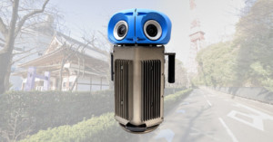
Google Street View is celebrating its 15th birthday by unveiling a brand new compact and lightweight camera system. This new camera weighs less than half of the current Google Street View cameras and is more customizable.
Google has expanded the immersion of its Maps app by combining street view with aerial imagery. It also showed a coming technology that utilizes a smartphone camera to provide information on real-time situations.

A Northrop Grumman B-2 Spirit stealth bomber has been caught flying over farm fields in the Midwest by Google Satellite cameras. It was spotted by a sharp-eyed Google Maps user.
Here is a little exercise to show how we can do things in this modern world. This is not one of those whacky geo-location stunts, this is just ordinary research, some simple geometry, and some careful guessing.

Creative Director Yousuke Ozawa—whose 'Satellite Fonts' project went viral back in 2014—is at it again. In order to keep his sanity during lockdown, he started taking "digital vacations" through Google Maps, and capturing Street View travel photography.

Today is Google Maps' 12th birthday, and graphic design student Matteo Archondis is paying the platform homage in a really cool way. A fan of timelapse and hyperlapse techniques, Archondis created a visual hyperlapse tour of the world using only screenshots taken within Google Maps.
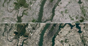
Google Maps and Google Earth just got a whole lot sharper thanks to NASA and its Landsat 8 satellite. Using beautiful high-res imagery captured by the new satellite, Google has built a better high-res cloud-free mosaic of the world based on some 700 trillion pixels of data.
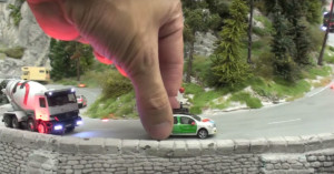
Google's Street View cameras have gone to the ends of the Earth, from under the sea to desolate deserts, in order to document the world in photos. The project is grand, but its latest effort is on a much smaller scale -- literally.
The company just announced Street View for the famous Miniatur Wunderland in Hamburg, Germany, the world's largest model railway. To shoot the images, Google mounted tiny cameras to tiny vehicles (they also had a tiny Street View car look-alike drive around).

picsbuffet is a new visual image browsing system that lets you explore and search millions of photographs through an interface that feels like Google Maps.
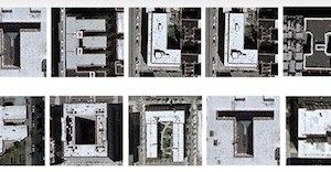
While browsing around on Google Maps satellite view (as many of us have done at some point or another) art director Yousuke Ozawa came across a number of buildings that resembled various letters of the alphabet.
Realizing the potential of this find, he spent the next week digitally flying across the globe and curating what ended up being Satellite Fonts, a collection of all 26 letters of the alphabet as formed by buildings across the world.
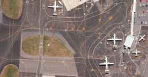
Airports are a common source of creative and interesting imagery. From time-lapses of the comings and goings to composites that pack hours worth of departures into a single image, the sheer scope and complexity of airports fascinates many creatives.
One such creative is Art Director Lauren O'Neill, whose photo series/Tumblog Holding Pattern reveals the intricacies of airports from above using Google Earth satellite imagery.
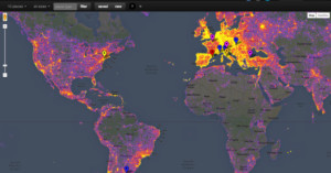
Two weeks ago, Instagram released its annual top 10 lists of the cities and locations that were photographed most often using the photo sharing service. But this year, Google has seen fit to one-up them by releasing a heat map that gives us a more visual representation of the most photographed places in the world.
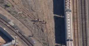
Google has agreed to replace a Google Maps satellite image of a Richmond, California railroad yard that may show the body of a murdered teenager.
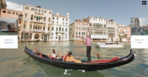
The Google Street View team went amphibious for its latest mission: a 360-degree capture of the canals, streets and piazzas of Venice -- the city many view as the most romantic on Earth Venice.
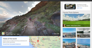
The launch of Android 4.2 in October of last year brought with it the ability to create special 360° panoramas called "Photo Spheres." But as cool as these panoramas were, there was no real way to share them with the exception of a widget Google released a few months back.
Yesterday, all of that changed when Google announced a brand new Google Maps website called Views, built from the ground up for the Android community and their many un-shared Photo Spheres.

Google has had no issues expanding street view to some pretty amazing places. Thanks in large part to the company's trekker backpacks, we can now visit the Grand Canyon, explore Central Park and check out the view from the world's tallest peaks.
But the company isn't above asking others to help expand the "off-road" street view repertoire, and so Google is announcing plans to loan out those expensive Trekkers to worthy third party organizations.