googlemaps

Street View Trekker: A Backpack-Mounted 360-Degree Camera Rig

Besides sharing some impressive specs at that Google Maps presentation we mentioned yesterday, Google also unveiled a new street view tool that should go a long way in further mapping out our world. The Street View Trekker, as they call it, is a backpack-mounted street view camera that allows the wearer to photograph and document places that can only be reached using the good ol' shoelace express. According to Engadget, the 40lbd Android powered backpack packs 15-megapixel cameras, an on-board hard drive, and enough battery to run for an entire day.

Shoot, Share, and Explore Satellite Photos of Earth with Stratocam

If you've always wanted to be an astronaut photographer shooting images of Earth from a window of the International Space Station, Stratocam is an app for you. Created by Paul Rademacher, it allows you to snap your own photographs inside Google Maps' satellite view of our planet. You can also view and rate other people's photos, and browse the highest rated images from around the world.

Kite Photos Used to Replace Shoddy Satellite Imagery on Google Maps

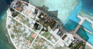
Frank Taylor, the guy behind the unofficial Google Earth Blog, is currently on a 5 years sailing trip around the world called The Tahina Expedition. Google is actually a partner in the expedition, and is acquiring content generated by the trip for use in their products. One thing Taylor has been doing is taking aerial photographs of locations using a kite, resulting in imagery that's much clearer than the photos Google gets from their satellites up in space. Google has already begun incorporating some of these images into their products, as you can see from this Google Maps satellite view of Manihi in French Polynesia.

Check out this Picasa album to see behind-the-scenes photos of Frank setting up his kite and shooting photos.