Google Maps Rolls Out AI-Powered ‘Immersive View’ in Five Cities

Google is making significant improvements to Maps, including a new artificial intelligence-powered (AI) “Immersive View” that is available for select major cities.
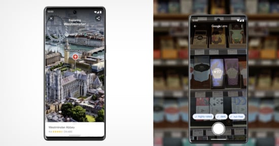
Nowadays, it’s hard to imagine exploring a major city without a smartphone. Apps such as Google Maps make it easy to explore new areas, learn about nearby landmarks, restaurants, and businesses, and plan exciting trips. Google aims to make navigation even richer and more informative in major cities thanks to Immersive View. The feature, first unveiled at last year’s I/O 2022 conference, delivers a more intuitive Google Maps experience thanks to advanced computer vision and artificial intelligence.
Immersive View fuses Google Street View and aerial images to craft a digital 3D model of an are. The digital model includes layers of information laid over a user’s surroundings and provides contextual information such as weather, traffic conditions, and how busy a location is.
Google offers an example use case: Suppose a user is planning a visit to the Rijksmuseum in Amsterdam. They can use immersive view within Google Maps to virtually explore the building, locate entrances, survey the weather, and find the busiest (and least busy) areas in and around the museum, including predictive information for congestion at different times of the day. If that person is hungry, they can virtually explore the area to locate nearby restaurants and even take a virtual peek inside.
The true-to-life scenery in Immersive View is possible thanks to neural radiance fields (NeRF). NeRF is an advanced AI technique that builds novel 3D representations with simulated lighting conditions using typical 2D images. Using NeRF, Immersive View promises to recreate a location’s textures and lighting accurately. It could theoretically be used to scout potential photo locations for environmental portraits or cityscapes, assuming the lighting model is accurate.
Are you the sort of person who needs to get the feel of somewhere before you commit? 🗺
With immersive view on Google Maps, you can see what a neighborhood is like before you even set foot there📍
✨ Coming to more cities in the next few months ✨#googlelivefromparis pic.twitter.com/VPvqHP25ai
— Google Europe (@googleeurope) February 8, 2023
While Google’s Rijksmuseum example is based in Amsterdam, Immersive View is rolling out in five different cities today, including London, Los Angeles, New York, San Francisco, and Tokyo. The hypothetical Rijksmuseum example will be possible in the coming months, along with Immersive View functionality in Dublin, Florence, and Venice.
Just the Latest Advancement for Google Maps
Immersive View isn’t Google’s first foray into photorealistic aerial views. The company added impressive aerial views of nearly 100 landmarks worldwide last summer. These aerial views were a significant first step toward the fully immersive experience that launched today. The library of supported landmarks increased to around 250 by the fall.
For residents and visitors to the five currently supported cities, Immersive View is available on Google Maps on Android and iOS. Google plans to bring the feature to desktop, although no release timing has been provided.
Google is also using AI technology to improve search functionality across many of its services, including Maps. In London, Los Angeles, New York, Paris, San Francisco, and Tokyo, users can use Search with Live View to find important locations and businesses in their area, including restaurants, ATMs, parks, and transit stations. The feature uses augmented reality (AR), so a user would only need to simply hold thier phone up and point it at their surroundings. Information about businesses within view will pop up on screen, including ratings, business hours, how busy it is, and more. Users can then tap on the screen to bring up additional information as needed. Search with Live View will be available in Barcelona, Dublin and Madrid in the coming months.
Google has also delivered a major expansion to its indoor Live View functionality. The feature was rolled out in 2021 to help users navigate especially challenging areas like airports. At the time, it was available at many airports throughout the U.S., plus airports in Zurich and Tokyo. Google has announced that the feature will expand to more than 1,000 new airports, train stations and malls within Barcelona, Berlin, Frankfurt, London, Madrid, Melbourne, Paris, Prague, São Paulo, Singapore, Sydney, and Taipei soon.
Finally, in pursuit of a more useful Google Maps experience for users on the move, users will soon be able to view glanceable navigation information via a phone’s lock screen. The feature will show updated ETAs and provide information for a next required turn. If a user veers off the navigation path, it’ll update automatically without needing to unlock the device. Glanceable directions will be available on Android and iOS “in the coming months” and will be compatible with Live Activities on iOS 16.1.
A complete list of all changes Google announced for Maps can be found on the company’s blog.
Image credits: Google