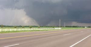
Satellite Photos Show What the Oklahoma Tornado Looked Like From Space
NASA has today released a series of images along with a video following Monday's devastating thunderstorms that produced an F-4 tornado (winds between 166 and 200 miles per hour) that touched down in Moore, Oklahoma. Several satellites were used to provide forecasters with the latest imagery.
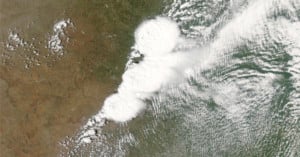
NASA's Aqua satellite was responsible for a visible-light image which provided a high-resolution look at the storm. The NOAA GOES-13 satellite provided images of the storm every 15 minutes, and the NASA/NOAA Suomi National Polar-orbiting Partnership satellite observed lightning from the system.