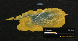
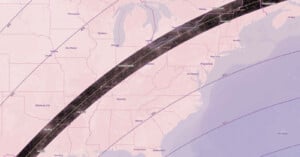
map

This Useful Map Reveals Photography ‘Hotspots’ Around the World

Landscape photographer and travel addict Mike Wong has created a super useful tool for fellow photographers who want some help location scouting. It's called "PhotoSpots," and it's an interactive "heatmap" that reveals photography hotspots around the globe and even pulls sample photos from those locations.

AirMap Lets You Look Up Where You Can Legally Fly Your Camera Drone

If you're getting into drone photography, it's important to know where you can and can't fly -- otherwise you could find your activities in the news for all the wrong reasons. AirMap is a new free, comprehensive, and interactive digital map that's designed specifically to help drone users find safe and legal airspace around them.

Mapillary is Building a Crowdsourced Street View with User Submitted Photos

Google's well-known Street View service is one of several monumental efforts to document the world's travel routes through ground-level photos. These projects generally use fancy camera rigs on cars, backpacks, and even camels to capture their images.

Mapillary is a startup that's trying to do things a little differently. Instead of taking the grunt work of photo-taking upon itself, the service is building a crowdsourced Street View competitor using photos submitted by users.

Skyfire Predicts and Maps Out Where the Best Golden Hour Light Will Be a Day in Advance

When you’re looking to get out and grab some landscape or sunset photography, getting the perfect light is usually a game of chance, but a new web app called Skyfire is looking to change that. By using a proprietary algorithm, Skyfire creates a heat map of light quality, ranked on a scale of 1 to 5, across the United States so you can find the perfect spot and plan your trip ahead of time.

Dark Sky Finder Helps Nighttime Photographers Find the Least Light Polluted Spots

For those of you who partake in any sort of nighttime photography, it’s no secret that light pollution can be the bane of your existence. Thankfully, there’s a neat, simple online resource that can help you better prepare to avoid this enemy of great Milky Way photography.

It’s called Dark Sky Finder, and it’s an easy-to-use website that gives you an up-to-date, radar-style view of what light pollution across the United States looks like.

Yale Project Makes 170,000 Depression-Era Photos Searchable with Interactive Database

Dorothea Lange's iconic Migrant Mother, pictured above, is just one of the roughly 170,000 photographs taken between 1935 and 1945 for a project commissioned by the United State’s Farm Security Administration and Office of War Information (FSA-OWI).

All of those photos are currently being stored in the Library of Congress, but a dedicated team from Yale University is looking to revitalize this invaluable collection of photographs by organizing them, pairing them up, and explaining how these images and photographers came together to create the most comprehensive looks at America following the Great Depression and into the early years of WWII.

This Interactive Map Shows Where You Can’t Fly Drones for Aerial Photography

Just got your hands on a drone and can't wait to use it to shoot aerial photographs? First, make sure you only use it where it can legally fly. If you're not sure where to look for this info, there's a new website designed just for you.

It's called Don't Fly Drones Here (DFDH), and is an interactive map that shows off limit areas of the US by shading them in with red.

Infographic Maps Out the Landscape of the Photography Industry

The company LUMA Partners has gotten in the habit of occasionally mapping out various industry landscapes to show how a product or service gets from Point A (i.e. the creators, marketers, businesses, etc.) to Point Z (i.e. the buyers, brands and publishers), going through the rest of the alphabet in between.

Taking a leaf out of their book, director of kbs+ Ventures, Taylor Davidson, decided to borrow their format and do the same thing for the photography industry, mapping out how content gets from the photographers out into the world of consumers, brands and buyers.

Photographer Visits Every Dot on the Map of North Dakota and Snaps 9,000+ Photos

A decade ago, photographer Andrew Filer obtained the most detailed map of North Dakota he could find, and began a project of documenting the towns on it. Not just some of the towns, but every single named dot on the map. After years of dedicated work, Filer succeeded in photographing the entire state. He ended up visiting over 850 different locations and snapping 9,308 photographs.

Big City Heat Maps of Local and Tourist Photo Spots

Two weeks ago we posted on the Geotaggers' World Atlas, a project by Eric Fischer that shows heat maps of where photographs are taken in big cities, created using geolocation data from Flickr and Picasa photos.

Fischer now has a new set of maps called Locals and Tourists that distinguish between photos taken by inhabitants of the city and others who are simply passing through.

Some people interpreted the Geotaggers' World Atlas maps to be maps of tourism. This set is an attempt to figure out if that is really true. Some cities (for example Las Vegas and Venice) do seem to be photographed almost entirely by tourists. Others seem to have many pictures taken in piaces that tourists don't visit.

Blue points are locals (determined by whether the person has a history of photographing in that city), red points are tourists, and yellow points indicate photos for which it cannot be determined.

San Francisco