Photographer Captures Northern Lights Over an Erupting Volcano
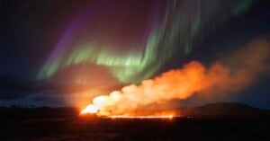
A photographer waited three years to capture these epic shots of the northern lights above an erupting volcano.
A photographer waited three years to capture these epic shots of the northern lights above an erupting volcano.
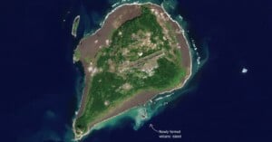
The "Earth's newest island" can be seen growing from space in newly-released satellite photos.
A pilot risked melting his drone to capture awesome shots of the recent volcanic eruption in Iceland.
An undersea volcano near the Pacific island nation of Tonga has erupted, sending an explosive shockwave by air and a tsunami by sea ripping across the Pacific Ocean. The eruption was captured in satellite images and is one of the most violent ever seen from space.
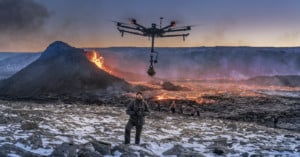
The Perlan Museum -- host of a state-of-the-art 8K planetarium and other exhibitions focused on Iceland -- commissioned filmmaker Ragnar Th. Sigurðsson, founder of Arctic Images, and drone pilot Arnar Þór Þórsson to fly an 8K-capable 360 camera over the erupting volcano to capture an immersive virtual reality (VR) experience.
Two filmmakers created a short film, "Volcano for the People," that explores the recent Iceland volcano eruption less as a natural phenomenon, but more as a collective experience that brings humanity together.
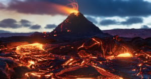
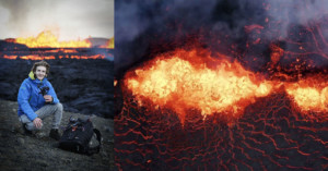
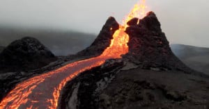
Photographer Mike Mezeul II has captured an incredible set of photos and a 3.5-minute video documentary that shows the size, scale, and majesty of Iceland's Fagradalsfjall volcano, which has grown dramatically in size since its appearance in March.
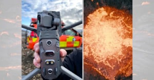
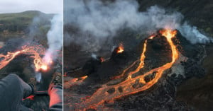
Photographer Garðar Ólafs -- and founder of the Iceland-based stock agency Airstock -- recently took his DJI drone to the skies above the erupting Geldingadalir volcano and may have gotten a little bit too close.
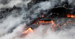
Iceland's erupting Geldingadalir volcano has been the subject of some exciting aerial footage and up-close images, and photographer Jeroen Van Nieuwenhove created a set of images and a short film that frames the natural event in a beautifully dramatic context.
While up-close photos taken of Iceland's erupting volcano are impressive, some footage captured by a drone is equally stunning.
It finally happened. Every year we’ve seen it on the news: another volcano in Iceland was going to erupt. The truth is: Iceland has so many volcanoes and there is more than one overdue. But this year we could feel an eruption was getting closer.
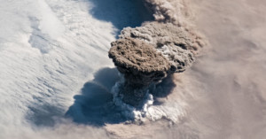
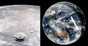
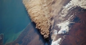
The Raikoke Volcano on Russia's Kuril Islands erupted this past weekend, sending a massive plume of ash and gas 8 miles (13km) into the sky from the 2,300-foot-wide (700m) crater. An astronaut onboard the International Space Station managed to capture a beautiful photo of the plume as the station orbited by 250 miles (402km) overhead.
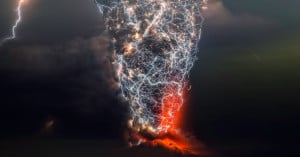
Francisco Negroni is a Chilean freelance photographer has spent years pointing his camera at volcanic eruptions. Over time, he has captured a series of incredible photos showing the lightning of "dirty thunderstorms" that are found in massive volcanic plumes.
The ongoing eruption of the Kilauea volcano on the big island of Hawaii has led to tens of thousands of evacuations and the destruction of tens of homes. And the eruption has grown to such a scale that it can now be easily seen from the International Space Station.
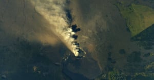
In September and October of 1994, the space shuttle Endeavour was orbiting 115 nautical miles above Earth while the Kliuchevskoi Volcano was spewing ash and dust into the atmosphere at an alarming rate. Not in any position to do anything about it, the astronauts aboard the space shuttle did the only thing they could do... they took pictures.
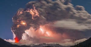
These images by Chilean photographer Francisco Negroni of the Cordón Caulle volcano erupting are so jaw-dropping and mind-blowing that we're finding it hard to come up with appropriate adjectives. Billowing clouds of ash are joined by spiderwebs of Volcanic lightning to create a light show that truly drives home Mother Nature's terrifying splendor.
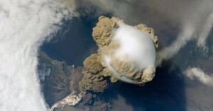
Since we've been talking about taking pictures of outer space, it only seems right that we share an incredible picture taken from outer space. This photo, taken by astronauts aboard the International Space Station, shows the incredible vantage point they were privy to in 2009 when they witnessed an eruption of the highly active Sarychev Volcano.