Satellite’s Final Photo Shows Las Vegas Has Doubled in Size Since 1999
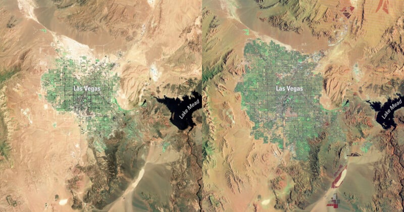
The Landsat 7 satellite has signed off on its 25 years of taking photos of Earth with one last image of Las Vegas showing that the City of Sin has almost doubled in size since the spacecraft first snapped it 25 years ago. Since its launch on April 15, 1999, Landsat 7 has captured over 3.3 million images, including the first image of Las Vegas, which was captured in July 1999.
Landsat 7 was developed and operated jointly by NASA and the U.S. Geological Survey (USGS). Orbiting the planet every 99 minutes, the satellite provided critical data used in urban planning, agriculture, disaster response, and environmental monitoring. It was originally expected to function for just five years but far surpassed that goal, continuing to contribute valuable imagery despite a significant instrument malfunction in 2003.
Its last image captures the Las Vegas metropolitan area, as well as the surrounding communities of Henderson, Paradise, and Spring Valley, which sprawl into the Mojave Desert. According to USGS, the region’s population grew by approximately 69% between 2000 and 2023, rising from 1.38 million to 2.33 million. In 2025, that figure is estimated to have reached around 2.4 million.
Visible in both the 1999 and 2024 images is Lake Mead, a reservoir formed by the Hoover Dam. The lake appears significantly smaller in the latest photo, a change that may be linked to regional water use or climate change. However, NASA’s Earth Observatory notes that natural seasonal and annual fluctuations also influence the lake’s size.


The satellite’s mission officially concluded on June 4, 2024, when it received its final transmission from operators following a year-long decommissioning process. In line with U.S. space debris mitigation guidelines, engineers lowered its orbit and depleted its fuel and batteries to prevent future collisions or accidental reactivation. Landsat 7 will now remain in orbit for about 55 years before reentering Earth’s atmosphere.
“Landsat satellites have delivered over 50 years of extraordinary science data, economic value, and national security benefits by informing decisions in every sector of the economy—from monitoring drought in the West to guiding disaster recovery,” says USGS Acting Director Sarah Ryker. “For 25 of those years, Landsat 7’s data helped farmers, land managers, city planners, and scientists, as well as communities around the world better understand and manage land, water, and other natural resources.”
The Landsat program continues with Landsat 8 and Landsat 9, which together image Earth’s surface every eight days. A next-generation satellite, Landsat Next, is currently planned for launch in the early 2030s, although its future depends on uncertain funding.
Image credits: USGS