The Inside Story of How NASA’s Odyssey Saw Mars in a New Way
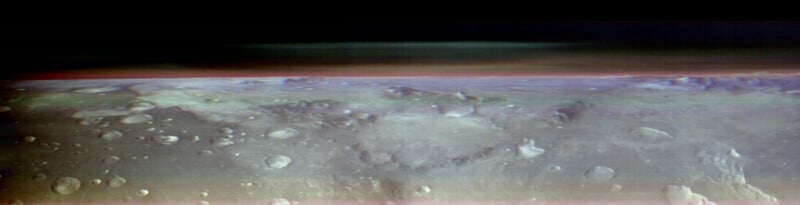
NASA’s Odyssey orbiter has captured a never-before-seen view of Mars, mimicking the perspective of Earth astronauts have from the International Space Station.
PetaPixel discussed the achievement and the technology that made it possible with Jeffrey Plaut, Odyssey’s project science at NASA’s Jet Propulsion Laboratory (JPL) in California. Plaut has been with Odyssey throughout its mission lifetime, nearing its 23rd year in Mars’ orbit.
Since the Odyssey spacecraft has been orbiting Mars since October 24, 2001, why did the team wait so long to capture images like this? Plaut explains that he and the team need to return to NASA every few years with a mission plan and objectives. This has numerous consequences.

Perhaps most importantly, a mission team must convince the powers that the mission deserves additional time and funding. While an original mission plan may include a lengthy operational window, it is not a given that a mission will last as long as intended, and plenty of missions have gone on much longer than initially expected.
These semi-regular meetings with NASA also mean that a mission’s team must stick to the plans it offers when soliciting more time and money. Every NASA mission must have worthwhile scientific goals and deliver on its promises.
In the case of Odyssey and its new orbital images, the team had to take these photos because it said it would when pitching its mission plan to NASA. However, just because the pictures were necessary to uphold a promise doesn’t mean that the photos are business as usual because they aren’t.
“Every few years, we need to come up with a plan for what we’re going to do scientifically with the next several years of the mission. Right now, we’re on a three-year cycle,” Plaut tells PetaPixel. “A couple of years ago, we had to write a proposal document to NASA to continue the Mars Odyssey mission for three more years. Among the things we put in that proposal were new kinds of observations, including exactly this.”
By “this,” Plaut means the complex planning and image capture that resulted in the novel new views of Mars, which includes “Pointing the spacecraft off to the limb, tracking the horizon to look at cloud structures and to look at the surface in the foreground to see how that perspective changed our understanding of the thermal emission from the surface and from the atmosphere. Those things were in our proposal, and we’re on the hook to do them.”
The scientific community and the world are better for it, no less. Beyond ticking off a critical box on his to-do list, his team’s achievement personally means a lot to Plaut.
“It’s one of those things that is why I love to be in this kind of work because it’s just super cool. We’re looking at Mars, a different planet, in a way nobody has ever looked at it before,” he explains enthusiastically.
“And that’s always a very exciting aspect of being a planetary scientist. No human eyes have really been laid on this part of the solar system in this particular way before, and we’re learning and seeing things in a different way for the very first time. So that’s really cool and gets you excited and gets you to come back to work each day when you can do stuff like that.”
This is such a vital point to zero in on. Odyssey has looked at Mars in a way that no imager ever has before. Further, achieving this feat was anything but straightforward.
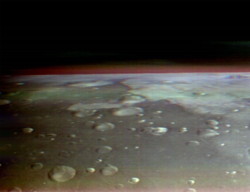
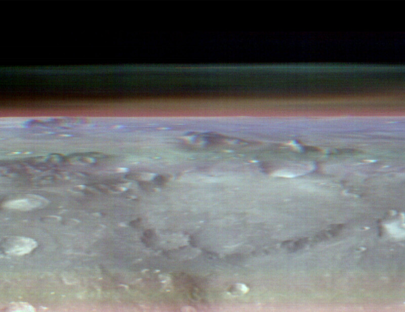
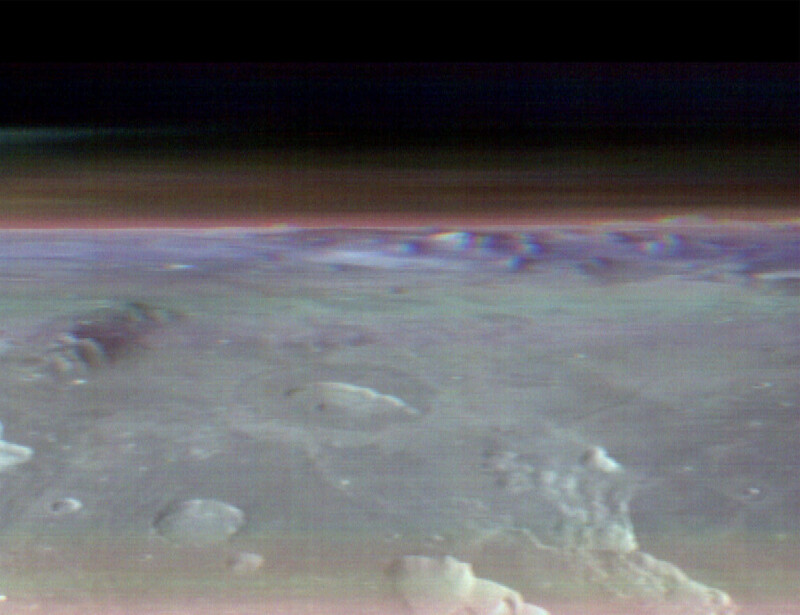
The Odyssey orbiter has a highly-specialized camera onboard called “THEMIS,” which stands for Thermal Emission Imaging System. The camera is designed with a particular purpose in mind: it is built to measure thermal emissions, hence the name, on the Martian surface to determine different mineral compositions on the planet’s surface and how these minerals and the overall topography of the planet and its geology relate to each other.
Without getting too deep into the weeds, the nature of the camera means that, unlike something like a regular digital camera, which resolves details thanks to visible light, THEMIS measures non-visible light — specifically infrared wavelengths. If someone has seen thermal night-vision goggles before, that is similar to how THEMIS works.
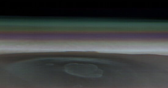
The image at the top of this article may look “normal,” for lack of a better term, but is far from it. The craters, bumps, and undulations on the surface are visible only because of how surface aberrations on Mars affect how infrared wavelengths, or heat, travel from the planet’s surface to THEMIS.
“Basically, [THEMIS] provides images of the temperature of whatever target it’s looking at. The story this week is about this observation that we made a few months ago now where we pointed that camera not down towards the surface where it’s normally pointed, but all the way off to the side. So, it captured the foreground of the terrain out to the horizon, and then the part of the sky above the horizon that contains the cloud layers,” Plaut explains.
“The colors in the foreground aren’t all that meaningful,” Plaut adds, noting that the image processing team was primarily focused on the colors in the clouds above the Martian surface. The image is constructed of three different infrared color channels, all well outside the spectrum that human eyes can see, so it’s a false-color image. THEMIS has nine various thermal infrared bands it can use to achieve its mineral-peeking mission.
The same reason that THEMIS is so adept at evaluating mineral compositions on the planet’s surface is also why it is able to, with this new skewed view of the red planet’s atmosphere, determine something about the chemicals in the clouds above Mars.
“But another capability that it has by having those multiple channels is it can look at the atmosphere and it can distinguish the composition of the materials in the clouds. We selected the bands so that they would distinguish between several different cloud types and they would wind up in colors that are sort of intuitive because they would like the visible colors, which are the dust layers that are lower and kind of hugging the ground. Here are these reddish-brown layers. Those are dust clouds. And then these higher altitude clouds, which are bluish, are water-ice clouds, similar to the clouds in the Earth’s atmosphere,” says Plaut.
Plaut is an invaluable resource for not only understanding Odyssey’s mission and Mars itself but also fully appreciating the latest images.
While some people may see the new image and think, “Oh, it’s just another image of Mars,” there is so much more going on here that is scientifically interesting and fascinating from an image technology perspective.
Looking at the terrain, Plaut explains that what people see is temperature. “It sort of looks like a photograph that’s illuminated by the Sun, and these are all craters. You can see that many of them have a bright edge and a darker edge. And that’s because the afternoon Sun was or still is shining on one side of the crater. We’re in a late afternoon orbit, and the Sun is very low in the sky, and so it’s only lighting up one half of the crater and the other half is in shadow, but you’re seeing the temperatures, that’s what the camera is sensitive to,” Plaut explains.
What THEMIS sees is not sunlight in an ordinary sense, the way that people see it, but the thermal effects of the Sun’s radiation.
“You’re seeing the warm side that is still being illuminated or was recently illuminated by the Sun, and it stays warm through the evening and into the night, and then everything kind of equilibrates in temperature. So that’s a lot of what you’re looking at looks like a topographic image, but really, it’s an image of the temperature and the topography controls the temperature.”
“Now then there are some craters where there are bright spots, warm spots on the floor of the crater…that is a result of those surfaces being somewhat different than the surroundings in the way that they retain their heat. So again, I think this part of the image is in the late afternoon or evening around 6:00 PM local time. And so some of these surfaces have been warming up all day long and they’re still warm.”
What Plaut is saying here is that the visible topographic detail is not the result of the way that visible light interacts with the surface of Mars, but how the heat from the Sun strikes the planet, is retained by different minerals and soil compositions, and is affected by the coarseness of sand and rock. While the detail here is reflective of and affected by sunlight, it does not show sunlight in and of itself.
“So you see this daily cycle of changes in temperature, and a lot of it depends on the material. We use that information in these thermal images to say, ‘Oh, is this a dusty area of Mars? Is this rock outcrop? Is this some kind of coarse sand or fine sand?’ And so apparently, in the floors of some of these craters, there’s some kind of probably coarser, higher density material that’s retaining its warmth well into the afternoon or the early evening compared to some of the surroundings that are darker and therefore have cooled off more.”
As is always the case, NASA’s missions represent incredible and crucial scientific work and demonstrate the diverse ways in which different imaging technologies can push the limit of human understanding further.
Image creditsNASA/JPL-Caltech/ASU