Posts Tagged ‘googlestreetview’

Street View Screenshots: Photography or Plagiarism?

Street View Screenshots: Photography or Plagiarism? sv mini

In 2011, photographer Michael Wolf was awarded Honorable Mention in the World Press Photo 2011 contest for screenshots taken from Google Street View. It immediately sparked a debate regarding whether or not the work should even be considered “original photography”. The Independent has an interesting article about a different Street View “photographer”: Jon Rafman, whose work we’ve featured here before.

At first, [Rafman] would spend eight to 12 hours at a time traversing the globe from his desktop. “It was destroying my body,” he says. But when the images he’d collected went viral online, he began to take submissions from other users, too. Some had collected images of prostitutes at work, others presented car accidents, even dead bodies left by the side of the road – and, presumably, ignored by Google’s drivers. Many of the images in the exhibition have now been wiped from the web: the perps lined up against a wall by the São Paolo police are gone from Google Maps. A man sitting with his legs splayed strangely around a lamppost in Toronto has been blurred into obscurity.

Rafman’s images, by contrast, are almost entirely untreated. He even leaves the Google Street View navigation tool in the top-left corner of each photograph. “The work is connected to the history of street photography,” he explains, “but also to the 20th-century ready-made movement. So leaving those artefacts in the image is extremely important. In the bottom-left corner of each picture is a link that says, ‘Report a problem’.

His work, titled The Nine Eyes of Google Street View, will soon be exhibited at London’s Saatchi Gallery.

Google Street View photographs: the man on the street [The Independent]

Google Street View Can Now Take You On Tours of Historical Sites in the Antarctic

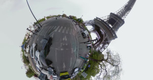
Google Street View is interesting from a photographical perspective because it is, essentially, the largest compilation of 360-degree images in existence. Photographer Michael Wolf even used it to get a different perspective on over-photographed Paris. The best photos on Street View, however, weren’t actually taken in the street. They come from endeavors like Google’s World Wonders project, which takes you on 360-degree tours of famous and often inaccessible locations. Read more…

Michael Wolf On His Fascination With “Peeping”

When photographer Michael Wolf had to move to Paris in 2008 because of a job opportunity for his wife, he wasn’t too thrilled with the situation. He thought that living in one of the most photographed cities of all time, surrounded by the inevitable cliches of such a place, wasn’t conducive to creative, unique photography. So he sat down at his computer and began browsing through the then only 6-month old Google Street View, which ultimately led to a unique photographical project that fit right in with his long-time fascination with “peeping” into people’s lives through photography. Read more…

A Tiny Planet Journey Around the World Using Google Street View

Chemin Vert is a project created by Italian artist Giacomo Miceli using photographs from Google Street View. It’s a journey through five continents over four seasons at a simulated 930 mph. The video above was created by mapping the Street View images as stereographic projections (i.e. “tiny planets”), but there’s also an interactive, immersive version of the project here.

Chemin Vert (via Laughing Squid)

Street View Trekker: A Backpack-Mounted 360-Degree Camera Rig

Street View Trekker: A Backpack Mounted 360 Degree Camera Rig googletrekker mini

Besides sharing some impressive specs at that Google Maps presentation we mentioned yesterday, Google also unveiled a new street view tool that should go a long way in further mapping out our world. The Street View Trekker, as they call it, is a backpack-mounted street view camera that allows the wearer to photograph and document places that can only be reached using the good ol’ shoelace express. According to Engadget, the 40lbd Android powered backpack packs 15-megapixel cameras, an on-board hard drive, and enough battery to run for an entire day. Read more…

Google Street View Has Snapped 20 Petabytes of Street Photos

Google Street View Has Snapped 20 Petabytes of Street Photos streetviewcar mini

Earlier today Google gave a sort of “state of Google Maps” address to many of the biggest names in tech, and one of the most impressive statistics to arise out of the presentation was that so far, Google Street View cars have driven over 5 million miles and collected over 20 petabytes of imagery. To put that in perspective, that means that the street view cars have travelled enough miles to complete 10 round trips to the moon (and then some) and have stored more than 80 times more information than is contained in the US Library of Congress. You think they have a few extra external hard drives lying around?

(via Engadget)


Image credit: Google Street view-bilen vid Örjanskolan! by jarnakommunikation

Your Own Personal Google Street View Camera Kit

Your Own Personal Google Street View Camera Kit diystreetview mini

Contrary to popular belief, Google can’t be everywhere at once (they’re working on it), and one of the most obvious examples of this limitation is the extent of Street View functionality in Google Maps. Of course, tons of roads and even some obscure neighborhoods have been mapped out with street view, but all too often your own front yard is left un-street-viewable. And while that may not be much of a tragedy for most people, those that would rather change that now have the option to with DIY Street View’s new Street View Camera System. Read more…

A Virtual Tour of the White House Using Google Street View Photography

A Virtual Tour of the White House Using Google Street View Photography whitehouse mini

Google recently brought its Street View camera inside the White House for the Google Art Project’s documentation of the artwork found within. In addition to displaying the art itself, the website also features a Street View-style museum view of the White House, allowing you to walk around inside virtually. Earlier this year Google did the same thing for photography mecca B&H Photo Video in NYC.

The White House – Museum View (via Coudal)

Strange Scenes Spotted by Google Street View Cameras

Strange Scenes Spotted by Google Street View Cameras street1 mini

Named after the fact that Google Street View cars shoot with 9 separate cameras, Canadian artist Jon Rafman’s Nine Eyes of Google Street View website is an ongoing project that publishes strange scenes photographed by Google’s automated cameras. Rafman writes,

This infinitely rich mine of material afforded my practice the extraordinary opportunity to explore, interpret, and curate a new world in a new way. To a certain extent, the aesthetic considerations that form the basis of my choices in different collections vary. For example, some selections are influenced by my knowledge of photographic history and allude to older photographic styles, whereas other selections, such as those representing Google’s depiction of modern experience, incorporate critical aesthetic theory. But throughout, I pay careful attention to the formal aspects of color and composition.

[...] I can seek out postcard-perfect shots that capture what Cartier-Bresson titled “the decisive moment,” as if I were a photojournalist responding instantaneously to an emerging event. At other times, I have been mesmerized by the sense of nostalgia, yearning, and loss in these images—qualities that evoke old family snapshots. I can also choose to be a landscape photographer and meditate on the multitude of visual possibilities.

Read more…

SeaView: Google Street View for the Sea

SeaView: Google Street View for the Sea underwater mini

New service called the Catlin SeaView Survey is planning to do for the ocean what Google Street View has done for land. Using a special camera, the joint venture between the University of Queensland, Google, and insurance firm Catlin Group will use a specially designed underwater camera to capture interactive 360-degree panoramic photographs. The purpose will be to carry out one of the most intensive studies of reefs ever, starting with Australia’s Great Barrier Reef. It’ll go into full swing starting in September, but some sample imagery is already viewable over at the SeaView website.

Catlin SeaView Survey (via Xatakafoto)