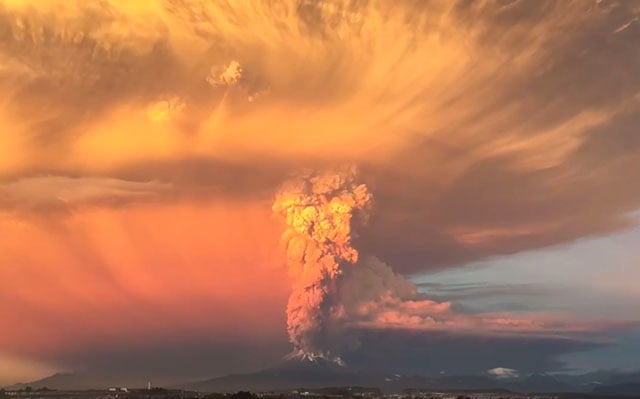
Nighttime Eruption of Kanlaon Volcano in Philipines Caught on Thermal Camera
A thermal camera has captured the moment a volcano in the Philippines erupted, sending ash almost two miles (three kilometers) into the air.
The Mount Kanlaon volcano sits on the Negros Island and a camera attached to the Upper Pantao Observation Station (VKUP) in Canlaon City captured the spectacular eruption.
The Manila Times reports that the “moderate explosion” took place at 2:55 a.m. and generated a grayish voluminous plume that rose two miles (three kilometers) above the vent before drifting to the general west.
LOOK: IP camera footage of the -03:00 AM, 13 May 2025 explosive eruption at Kanlaon Volcano captured by the Upper Pantao Observation Station (VKUP) in Canlaon City shows multiple pulses of explosive activity that generated incandescent columns that collapsed to form pyroclastic… pic.twitter.com/3zm8iN487Z
— PHIVOLCS-DOST (@phivolcs_dost) May 13, 2025
The Philippine Institute of Volcanology and Seismology (PHIVOLCS) says the moderate eruption happened at the summit crater of Kanlaon Volcano, lasting for five minutes according to the seismic and infrasound data.
“The eruption generated a grayish voluminous plume that rose approximately 4.5 kilometers above the vent before drifting to the southwest,” PHIVOLCS says.
Ashfall was reported in at least nine villages southwest of the Kanlaon volcano on Negros Island, though no injuries or property damage occurred.
The alert level remains at three out of five — a status first issued during Kanlaon’s eruption in December. Authorities continue to enforce a 3.7-mile (six-kilometer) exclusion zone around the volcano.
This alert level indicates ongoing magmatic unrest, suggesting a heightened risk of short, moderately explosive eruptions that could pose volcanic hazards.
Kanlaon also erupted briefly in April.
During its December eruption, thousands of residents were evacuated to emergency shelters as volcanic activity persisted.
Standing at 7,988 feet (2,435 meters), Kanlaon is among the Philippines’ 24 most active volcanoes. In 1996, an unexpected eruption claimed the lives of three hikers near the summit, with several others later rescued.
The Philippines sits along the Pacific “Ring of Fire,” a seismically active zone known for frequent earthquakes and volcanic activity. The country also experiences around 20 typhoons and storms annually, making it one of the world’s most disaster-prone nations.
Yesterday, PetaPixel reported on a security camera that captured the first-ever view of the Earth’s surface shifting along a major fault line during a powerful earthquake.
Image credits: Photographs by The Philippine Institute of Volcanology and Seismology.