Photos From Orbit Emphasize the East Coast’s Record-Breaking Cold
North America has been subjected to some of the most extreme cold in recorded history and views from space emphasize how frigid a couple of major U.S. cities have looked in recent days.
As explained by the European Space Agency (ESA), record-breaking Arctic weather swept through large swaths of the United States ii the last few weeks. Ice storms have shut down cities across the country, from Portland, Oregon, down to Oklahoma City. Farther north, in Canada, temperatures dipped so low that Celsius and Fahrenheit readings were almost the same.
As dramatic as the weather has been all over, the eastern portion of the United States were particularly affected as thick snow and low temperatures blanketed most of the region.
“The harsh winter weather led to travel warnings, road closures, and schools having to be shut. More than 100 million people were on windchill alert. Heavy snowfall officially ended the almost two-year-long absence of snow in cities such as New York, Philadelphia, Baltimore, and Washington D.C,” the ESA writes.
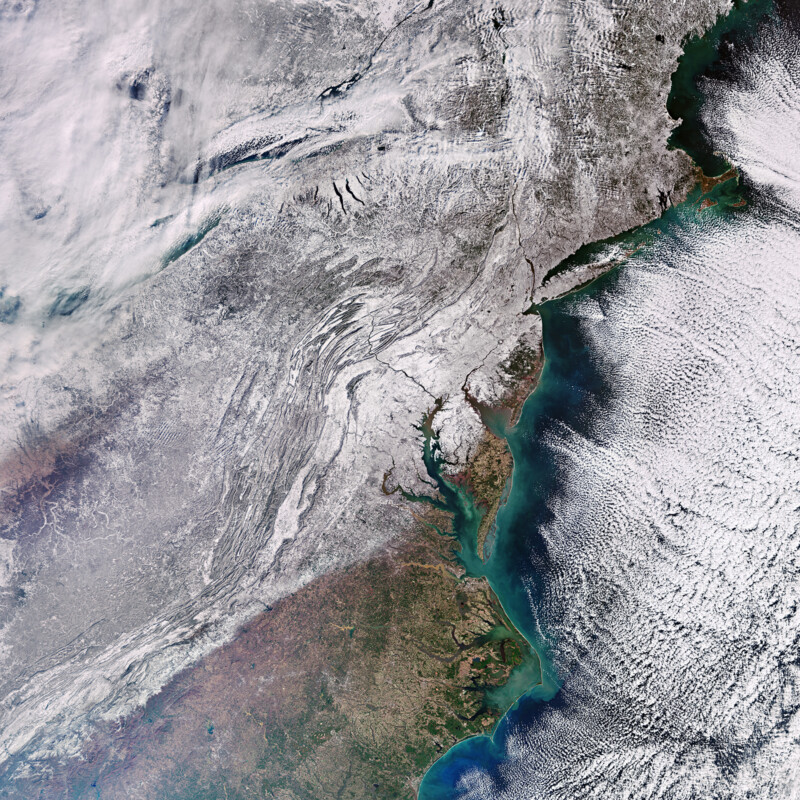
In the photo above (taken on January 17 by the Copernicus Sentinal-3 orbital satellite), all four of those cities can be seen blanketed under “a white mantle,” as the ESA puts it, making the region look more reminiscent of a tundra than the climate the area has become used to. The cold temperature affected even regions significantly south of the Northeast, spreading as far down as South Carolina.
“In the top left corner, the land around Lake Erie and Lake Ontario is blanketed with snow, while thick cloud blocks most of our view over the lakes. The snow-clad Appalachian Mountains are clearly visible stretching across the image from southwest to northeast, almost drawing a separation line between the white landscape and the snow-free area in the bottom of the image,” the ESA continues.
“Along the coast, different colors tint the ocean water. The color variation is down to different concentrations of sediment and algae: light blue to green denotes a higher concentration and dark blue indicates deeper waters where suspended material is more dilute.”
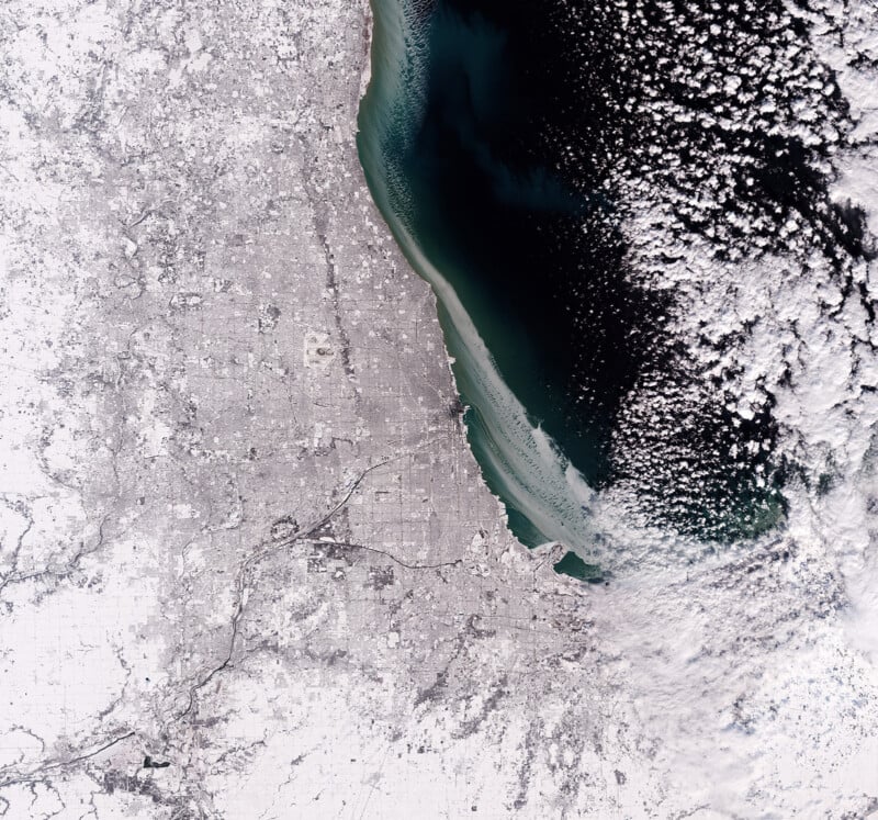
Chicago, which is no stranger to cold weather, also experienced a powerful storm. The photo above, captured by the Copernicus Sentinal-2 orbital satellite on January 20, shows the extent of the snow and even shows a layer of ice starting to form on Lake Michigan.
Both images can be seen in full resolution (the whole eastern seaboard here, with Chicago available here) for those who want to take a closer look at the regions. This winter has been cold and harsh thus far, and there is still more than a month left before the first official day of Spring.
Image credits: Photos via Copernicus Sentinel data, processed by the ESA