A Satellite Accidentally Captured This Extremely Cool Photo of the Moon
Studying the Sun is crucial for monitoring space weather, as events like coronal mass ejections (CMEs) can disrupt satellites, power grids, and GPS navigation. And yet this scientific research can create beautiful art.
Recently, the National Oceanic and Atmospheric Administration (NOAA) captured something magnificent on one of its coronagraph telescopes, a specialized instrument for monitoring the Sun that records images much like a normal telescope.
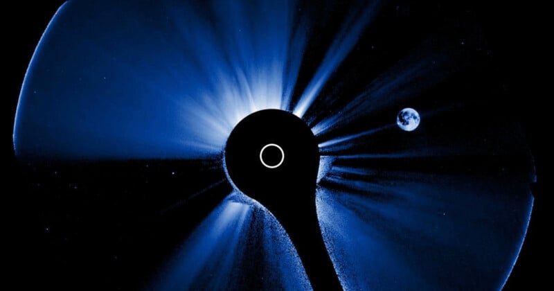
A coronagraph mimics a solar eclipse by blocking out most of the sunlight using a disk. This is so researchers can study the Sun’s outer light, known as the corona, which is hard to see when viewing the entire Sun.
Space.com explains that NOAA’s Compact Coronagraph-1 (CCOR-1) is attached to the GOES-19 satellite, a geostationary satellite which orbits the Earth at the same rotational speed as the planet, staying fixed relative to a point on the equator.
The CCOR-1 captured a spectacular shot of the Moon crossing directly in front of the Sun. Space.com notes that because the CCOR-1 is the closest coronagraph to Earth, its field of view will occasionally capture the Moon.
The Moon is fully illuminated in the image, and that has nothing to do with the lunar cycle; instead it is because of Earthshine, which is sunlight being reflected from Earth and onto the lunar surface.
The flash in the video above is also due to Earthshine. NOAA explains that twice a day the Earth “photobombs” the CCOR-1’s field of view due to the strong reflection of sunlight.
Satellites regularly capture unique images from above Earth. Earlier this year NASA’s Operational Land Imager (OLI) onboard Landsat 8 captured a remarkable image showing the summit of Mount Vesuvius peeking through a cloud blanket.
As well as monitoring space weather, they can also assess Earth’s environment. Satellite images laid bare the destruction of the Los Angeles wildfires in January. While in May, the MODIS (Moderate Resolution Imaging Spectroradiometer) on NASA’s Aqua satellite captured images showing the demise of the world’s largest iceberg in the remote South Atlantic Ocean.
Image credits: National Environmental Satellite, Data, and Information Service,