The Breathtaking Size of Hurricane Erin Captured From Space in 4K
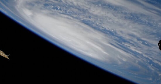
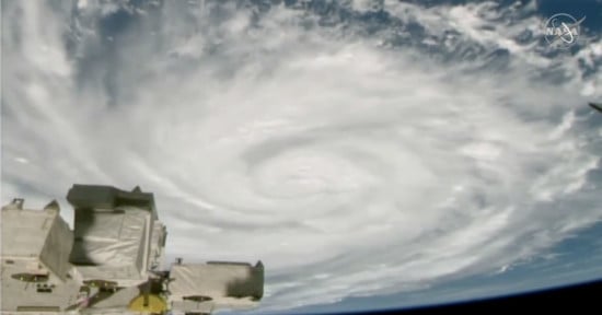
A camera attached to the International Space Station (ISS) has captured a frightening view of Hurricane Erin, which meteorologists fear will bring life-threatening storm surges to the United States this week.
Hurricane Erin is currently raging in the Atlantic Ocean and has been labeled “unusually large” by the National Hurricane Center. The New York Times reports that Erin is 530 miles wide, about 230 miles wider than a typical hurricane. Tropical storm-force winds have been felt 320 miles from its center.
The eye of Hurricane #Erin filmed from space 1 hour ago 🌪️#HurricaneErin pic.twitter.com/JyzXE5NXFY
— sen (@sen) August 20, 2025
The Sen Space TV-1 camera system — a trio of ultra-high-definition (4K) cameras installed externally on the ISS’s Bartolomeo platform — captured the epic view of Erin yesterday (August 20) at roughly 4.30 P.M. UTC. The same system that has captured mysterious symbols in a Tunisian desert and a Starship rocket launch from Texas
Erin is the only major hurricane of the year, so far. It has menaced the Outer Banks of North Carolina, causing storm surges that closed vital highways. Erin is projected to avoid hitting the eastern United States but it remains perilously close to North Carolina’s coast. Forecasters have also warned that potentially life-threatening floods could still hit the mid-Atlantic coast. The Category 2 storm has forced cruise ships to reroute.
“Significant impacts could linger into Friday due to lingering powerful swell energy and elevated tides/water levels,” the National Weather Service warns.

A spectacular view of Hurricane Erin swirling north as lightning flashes throughout the system. pic.twitter.com/tfno3tQ4Qo
— CIRA (@CIRA_CSU) August 21, 2025
On Monday, PetaPixel reported how the 53rd Weather Reconnaissance Squadron, known as the “Hurricane Hunters,” flew into Hurricane Erin’s eye, capturing mind-bending images of the “stadium effect.” The effect is named this because the encircling towering walls of clouds look like a sports stadium’s seating.
Last night, the 53rd Weather Reconnaissance Squadron flew into the eye of Hurricane Erin—and captured imagery of the breathtaking stadium effect.
These missions provide critical data to the NHC to improve forecasts, helping keep communities safe before the storm makes… pic.twitter.com/RpAs7yMDRf
— Hurricane Hunters (@53rdWRS) August 16, 2025