The Bloomingdale Trail
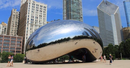
It’s a stark divide. In front of me, a man snores softly among a pile of beer bottles, yet somehow manages to sit upright on the edge of a slab of broken cement, not far from the edge of the crumbling bridge I’m standing on. Just beyond the bridge and barely 30 feet below lies a line of townhouses; each easily sold for over half a million. They stand sentinel-like, crowding each other, overlooking an old, unused elevated railroad embankment. Between the snoring man and I lie old rails, overgrown grass, and gravel. To the east, Chicago’s downtown skyline towers over the flat Midwest expanse. Welcome to The Bloomingdale Trail.
The line runs through a heavily populated area of a dense city, and over the years, people have clambered up onto the embankment and explored, more so in the past few years as more and more people have noticed the ghost elevated line that runs over streets and behind houses, bisecting neighborhoods and breaking up the city’s ebb and flow. But despite its interruptive nature, if you’re not actively looking at it and wondering what it is, the line fades into the urban backdrop. In fact even though I’ve lived around the line’s ruins for close to a decade, it’s taken a long time for my brain to wonder what purpose the crumbling viaduct running over Damen Avenue served, but even then I didn’t consider what was up there. It wasn’t until I was walking south on Damen towards the Wicker Park neighborhood that I noticed movement at the top of my line of sight where there shouldn’t be any. That’s when I spotted a lone jogger clad in a white running shirt and blue shorts, wearing sunglasses. It shocked me. Were people allowed up there? What was that thing? How did he get up there? I didn’t even know what it was called; no signs indicate what the raised land is for. Rusty railings appear erratically on its edges, most falling over at weird angles. In many of the spots where you can see the line clearly, the city’s houses and buildings all push right up against it, especially in the higher end neighborhoods where space is at a premium.
But after I noticed it I knew I had to get up there. Thoughts of how to climb onto the embankment consumed my free time. I consulted Google Earth, zoomed in on familiar streets and landmarks, eventually figuring out the location of the trail by correlating what I knew with the geographically null spot in my head. I zoomed in, feeling a flutter of excitement; for the first time I could see what the embankment was. Even with GE’s limited resolution I could see the old steel rails, and how overgrown everything was. I followed it from its eastern beginnings where the Kennedy Expressway and Ashland Avenue meet up, to its western terminus, which seemed to be some sort of train yard. The bad news? There didn’t appear to be any obvious ways to get up there, at least that Google Earth was willing to give up. The good news? After some searching, I eventually ran across it’s (then) unofficial name: The Bloomingdale Trail.
Spurred by the excitement of it all I wanted to run out and attempt to find an access point immediately. Unfortunately it was after midnight on a weekday; exploration would have to wait.
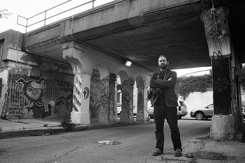
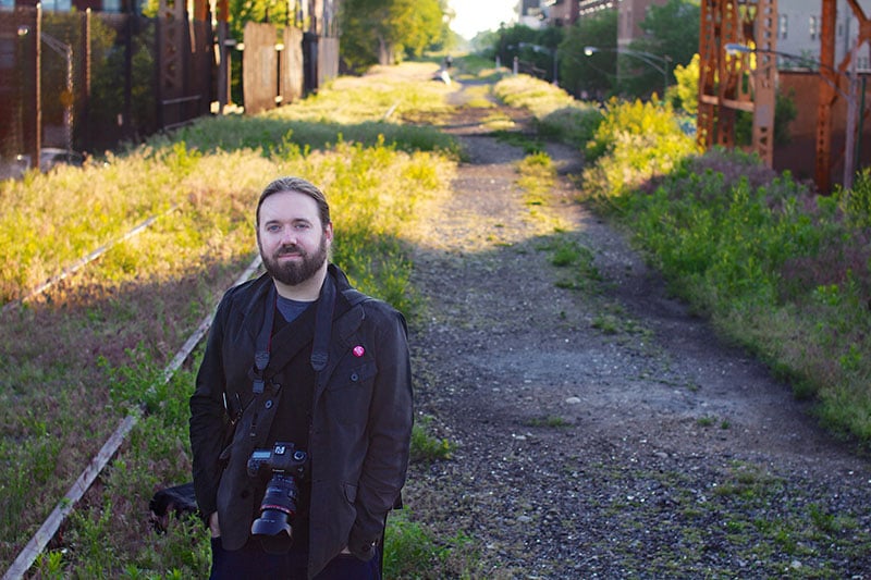
I ran across David Schalliol’s name when doing some research into the background of The Bloomingdale Trail; his photos of the various locations on and around the trail kept popping up. It turns out he became the go to guy for trail imagery when a grassroots organization called Friends of the Bloomingdale Trail reached out to him, interested in his photography: specifically, in helping them document the state of the trail in its current form, and continuing on, as they worked towards their goal of turning the old Bloomingdale Line into an elevated, linear public park. “I’d love to create a project or create a structure wherein I’m making space and time to think more seriously about the place instead of just approaching it as some sort of ad-hoc experience,” he told me. “Really try to think more conceptually and a little more seriously about what the place is, what it’s role in the future might be, and also to think about what’s the value of producing a photographic record of a place before (in this case several years before) any major transformation were to occur.” With a heavy background in sociology informing his photographic work, it’s quickly obvious that his images are more than just snapshots or thematic pieces with narrative threads; the images cut a cross section of themes and ideas all influenced by the abandoned railroad.
The ad-hoc part of the description rang true with me. It must, with most people. You see a mysterious place in the center of a dense, urban area, and your curiosity takes over. Thoughts about the history of the trail, or how it fits in with the city in its current and future state aren’t really the initial draw; the exploration of it is. Fortunately, the Friends gave him an opportunity to go beyond straightforward exploration and provided a framework enabling him to delve into the impact the trail had beyond merely a fun outlet for urban exploring.
The next day after work I packed a backpack with two energy bars and my camera, and set out to get up on the trail. I considered what might be the best ways to access the trail and ended up choosing a section that ran over Leavitt Avenue, a small, one-way residential street. Other streets that I could think of either had sheer cement retaining walls, steep embankments, or building properties that blocked access, usually with high fencing. Leavitt had some fencing, but the embankment was much more gradual and there was a break in the buildings; I reasoned that I could either find a way over the fence or walk along it until an opportunity presented itself.
Leavitt turned out to be a good choice. Climbing up the slope I stopped at the fence and looked around. I could make out the tracks on the other side and the rails disappearing both east and west into the distance, sandwiched between a seemingly endless string of buildings. The fence stopped where the bridge over Leavitt began, and after testing the strength of the fence (newly placed iron fencing most likely to keep trespassers out), I grabbed a hold of the bars, swung around the edge, and landed softly on the trail.
The moment I stepped out from the shaded slope and onto the straight expanse of the trail, that flutter of excitement from the previous night ran through me again. I stood facing east and saw something rare in Chicago – a straight, empty lane, lit by late afternoon sun, devoid of people and cars, right in the middle of the city.
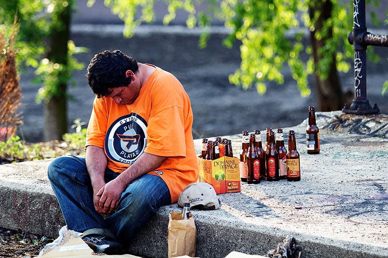
And that’s when I heard the snore.
It wasn’t a loud snore – just slow, heavy breathing. Just behind where I had swung myself onto the trail, a man in a bright orange shirt sat on a small cement block with his eyes closed, head dipping into his chest. Scattered around him laid numerous empty beer bottles, along with some unopened bottles in a six pack. He didn’t seem to notice me, or if he did, he couldn’t care less. Now I’m not shy in approaching people (it comes with the territory of shooting street photograph, of which I am a giant fan), but speaking to him didn’t seem all that useful or appropriate. So I did what came naturally – I pulled my camera out of the bag and took a shot.
It was an odd feeling. Like I said, I shoot a lot of street photography. I fall right in the middle of the confrontational scale in that I don’t hide the fact that I’m shooting someone, but I also don’t get all in someone’s business for a shot. But this felt different. The environment was foreign: here I was, standing thirty feet above the ground, in a busy city, but very isolated by nature of elevation. Technically I was trespassing. This was illegal. This man was drunk, relatively early in the day for that. The eyes of numerous people could be peering at us through windows directly abutting the trail. Or no one could be looking. Who knew?
I lowered the camera to consider the situation, and it dawned on me that the trail could easily harbor an unsavory crowd. To what extent I couldn’t judge from one minute up here, but it brought up some follow up concerns; what if I needed help? It wasn’t easy to get down at arbitrary points on the trail and what if I was injured? The trail’s state of disrepair meant injury was a distinct possibility, and it’d be difficult to explain to someone how to get to me.
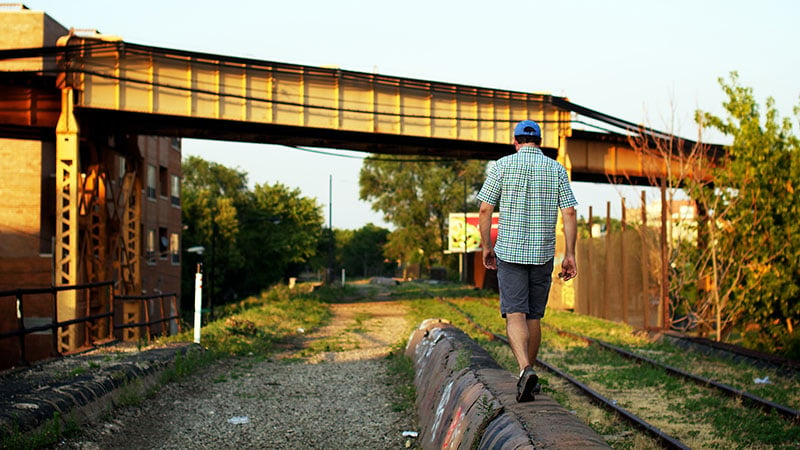
I looked east. According to Google Earth the end of the trail terminated just under a mile away at Ashland. In the distance, Chicago’s Loop beckoned, the straight line of the trail leading the way. I looked back over my shoulder at the snoring man, then started walking forward.
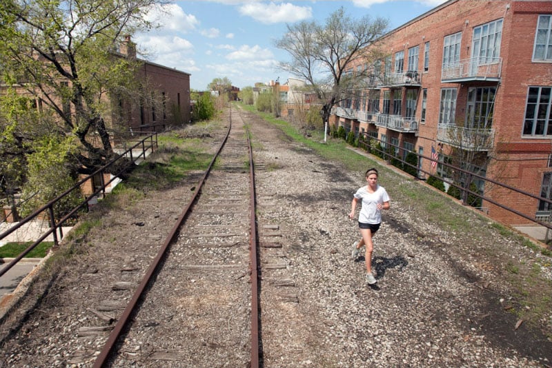
David’s walked the trail more than fifty times; enough to lose an exact count. “A typical day of working along the trail or on the trail would involve walking at least half of it, but it depends on what section I want to focus on, what time of day it is, what’s going on, and so on,” David told me. “I say every few times I’ll walk from end to end and back just walking along and working, and then other times will be more targeted.” The Bloomingdale Trail is very, very straight – straight enough that I could make out an actual vanishing point on the horizon that wasn’t broken by buildings, cars, or people – but it’s particularly ruler edge-like here. This part of the trail was at the southern edge of Bucktown’s border with Wicker Park. Both neighborhoods are dense and command high real estate values, and for the trail that meant the homes and condos pushed right up to the trail on both sides. Some parts were so dense with buildings and homes that it felt like you were walking in an alley; the gap between the edge of the trail embankment and some of the buildings were less than an arm’s length. It took actual effort to not look onto people’s porches, kitchens, living rooms, and bedrooms, not because there were spectacular residences (of which there were plenty), but because all the un-curtained windows and porch doors gave the distinct impression of a person walking down a street and peering into store displays.
From the beginning, David tried to approach the project as more than just “photographs on the trail”. He wanted to consider how this particular piece of constructed land connected with the surrounding community and the kind of role it played. “Is there something special about it being a little elevated but still very much part of the neighborhood? I started thinking about those sort of questions from the outset.”

I’m guessing that buying property that looked onto the trail gave you a bit of a discount. Maybe not much, but when the view through the window over your kitchen sink is an overgrown railroad with bits of graffiti, I can’t imagine it being much of a selling point. And what did the owners of those homes think of me walking by? Were they resigned to the fact that yet another person decided to trespass up here? Did they look at me and give me an instant once over, slotting me into a column for people that were annoying, but “at least he doesn’t look like someone that’ll tag the side of my building”? I caught the eye of someone sweeping their porch decorated with a set from Restoration Hardware. I barely registered to him, and he went back to sweeping. No friendly wave, but no angry yell either. I took it as tepid tolerance.
This particular stretch of the trail had a number high number of close-in condos, and visually it was quite boring; the city equivalent of McMansions with no real sense of personality. My thoughts drifted back to the snoring man. I suppose if you needed a place to drink but don’t have anywhere to go this was a pretty good place. I didn’t think cops patrolled regularly up here, and he wasn’t close enough to any of the beautiful condos to illicit any complaint calls from people glancing out their windows. But what struck me was that he was only a few hundred feet back in the direction I came from; right here a man fastidiously took care of a high end outdoor furniture set. Who knows – maybe earlier, the sweeping man had been reading a book in one of the lounge chairs and spotted the orange shirt man walking by. The two sat at polarized extremes, but something about the trail made it all seem… natural. Not in any kind of exploitive, “look at that man!” kind of way. It just seemed to be a direct result of landscape and geography which made both of them part of a community.

“I really wanted the linearity to be more of a connective tissue,” David said. “It’s important to think about how the trail’s been used.” I thought of how for one man, the trail offered the opportunity to drink without being bothered, and for another, a quiet backdrop. For both, it gave a bit of respite.
I ran into a jogger around the part of the trail that went over Damen Avenue. Actually, I should say I spotted him a good distance away, but we didn’t cross until the Damen viaduct. He looked like any other urban jogger: yellow running shorts, a black tech shirt, headphones plugged into ears. He glanced at me with a blank look and didn’t slow down; the next moment he was gone. A part of me wanted to call out to him and ask questions. How’d you get up on the trail? Do you run up here a lot? Do you know what this thing’s called? Why’d you start running up her? But the funny thing about the trail that I began to realize is that social interactions subtly change up there, and David pointed that out. “There is a different experience of bumping into someone up there than it is on the ground,” he said. “I think part of that has to do with that sort of illicit or maybe illegal activity, and that there may be a shared mistrust, and a shared connection of transgression that happens. But at the same it’s so normalized, and for so many people it’s just part of life to be up there.”
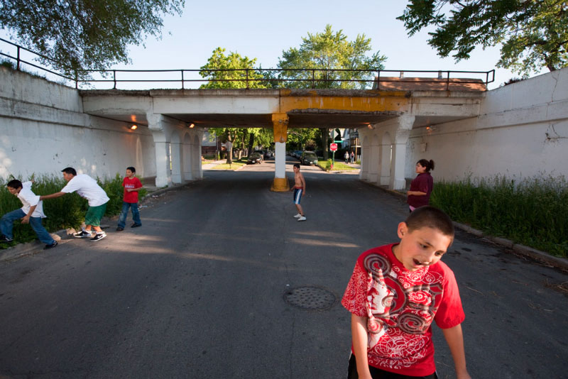
That’s when I noticed a bunch of teenagers yelling and waving for my attention down on Damen’s sidewalk. I walked closer to the edge (but not too close – there was no real railing) and peered down at them. “How’d you get up there?” they yelled.
“Leavitt,” I answer, and pointed west. They glanced in that direction but from here there was no straight shot at street level; there were too many people’s backyards to simply walk along the embankment. Cutting through the neighborhood to get to where I jumped on the trail required plenty of zig-zagging. One of them shrugged, losing interest, and they began to walk away… though I heard one of them mention how he could probably figure out how to climb up, and urged everyone to follow him while he searched for an access point. They disappeared under the viaduct and I wasn’t sure if they went along with his idea or not.
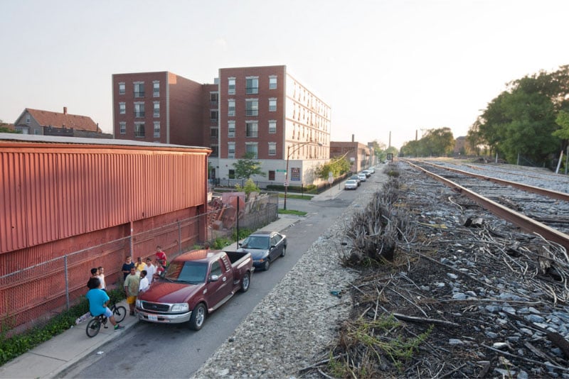
The trail’s east side abruptly ended just as it crossed over Ashland Avenue. A dirt and gravel pad with a broken chain link fence laid below Interstate 90/94, which soared cathedral-like above. Next to the pillars supporting the expressway were signs of outdoor habitation – a mattress or two, tarps loosely held up by rope, scattered clothes, some garbage – but no one was in sight. I hesitated to poke around; I had the distinct impression that I was about to enter someone’s personal area, which is of course a bit hypocritical, as I’d been trespassing this entire time.
One of David’s photographs showed a couple in that exact area, recently homeless and from the suburbs. “They sort of cleaned up that area. They had spent a considerable amount of time pushing the debris all to the side, cleaning up the area, and setting up an encampment in there. One of the reasons I continue to show that work… is that it’s important to think about how the trail’s been used and they are by far not the only people using the site in that way.” Questions swirled through my head. How did they find this place from all the way out in the suburbs? Why here?

I look past the broken fence and decide not to investigate. I turned around and headed back the way I came.
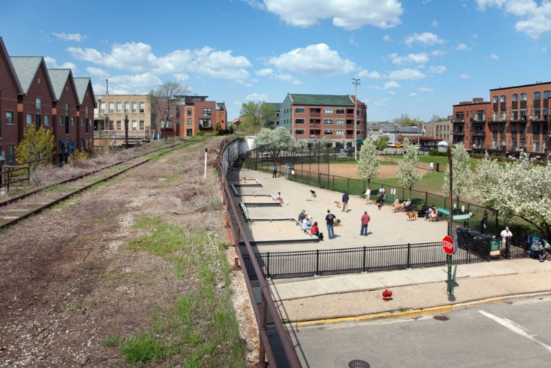
On the way back I stopped to look down into Churchill Park, a small, fenced in area for dogs that comes right up to the trail’s retaining walls. Tons of people and dogs roamed inside, encouraged by the warm weather, and I felt the palpable buzz of activity even from up on the trail. It was a park I had passed by plenty of times before in the past, but the vantage point from above gave a new perspective on it. I tried a few shots from different positions and angles, but I never managed to get a photo that I felt captured the visual spin of being elevated above. David, who shoots primarily with a 70-200mm and a 24mm tilt shift had an interesting solution to exaggerating and highlighting this perspective shift. “I’m often up there with the camera. Maybe with a tripod. And sometimes, I’m carrying a ladder.”
I laughed when he told me this; the idea of someone carrying a bulky ladder up to the trail seemed arduous. He wasn’t surprised by my reaction either. “The ladder generates a lot of laughs,” he said. But the simple technique of climbing up on the ladder paid off in many of his photos. Because the buildings near the trail were so close to the edge, it was hard to highlight the trail’s elevated nature. It just seemed like any other old abandoned railroad track. “If you can get six to ten feet above the trail, you can produce a different kind of vantage point, where you can get a better sense of the horizon and the relationship to where the park is,” he explained. “It’s such a long park – or will be a park – 2.7 miles. It provides all these really nice opportunities to get a sense of how far it goes and where it goes, and when you’re up a little higher, it makes it easier to see the way that the line runs above, but is still part of and defines the neighborhood.”
But he didn’t just want to shoot from the trail. “What I tried to do with the photography is of course highlight life or the experience of being above, but also there are a good number of pieces in the project that are about looking at the trail, looking from the trail into the neighborhoods, and so on.”
By the time I returned to my access point at Leavitt the sun had long since set and twilight begun descending on the trail. Even though I wanted to explore the western end, I knew it’d be better if I came back another time.
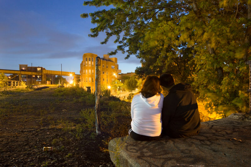
The snoring man had apparently moved on, taking along the bottles – no stray empties, no broken glass. I sat down on the cement block where he had been relaxing earlier and looked down the trail. Yellow dots of light from windows began to flip on, and not more than a minute later, the streetlights flicked on and lit parts of the trail. In Chicago, the lights are high pressure sodium vapor based; if you’re a photographer shooting near one of these things it’s a nightmare to get anything close to accurate color. That said, the warm glow of the lights, both from the windows and streets, made the trail feel inviting.

“It’s part of people’s private experience of Chicago,” David told me. And he’s right. Walking along the Bloomingdale Trail made for an insular experience. On one hand there was no doubt I was still in the city, surrounded by buildings and people. But at the same time I moved in a bubble. Save for the few people I came in direct contact with, there was no way for the people on the street to directly approach me. The people I did run into seemed to know that as well, and we all stayed within our own thoughts; we all silently agreed to leave each other alone provided we weren’t bothering anyone. David continued, “It’s not the experience of a public place. It’s the experience of a more private, personal and many times reflective or some other kind of space where people leave the streets and head to this different vantage point.”

In short order this crumbling bit of infrastructure will be cleaned up, paved over, and transformed into what I’m sure will be a beautiful urban green space. Cyclists, pedestrians, adults and kids – we’ll all be able to access it easily and move just above the city. But for now, it’s a quiet, contemplative space, raw, and full of memories.
Visit photographer David Schalliol to see more of his work, including his photographs of The Bloomingdale Trail