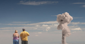
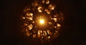
Satellite Photos Show the Extent of North Korea’s Uranium Mine Collapse
A North Korean uranium mine used to help make nuclear bombs has partially collapsed with satellite photos showing the extent of the damage.
Lieutenant Dan McGovern stands amid the wreckage in Nagasaki, Japan at precisely the spot an atomic bomb had landed a month earlier. McGovern has a camera in hand, documenting one of the 20th century's most significant events.
This is a photo of an atomic bomb milliseconds after detonation, shot by Harold ‘Doc’ Edgerton in 1952 through his Rapatronic (Rapid Action Electronic) Camera.
The photo was shot at night through a 10 foot lens, situated 7 miles away from the blast, atop a 75 foot tower. Edgerton systematically turned on and off magnetic fields acting as the camera’s shutter, as opposed to a conventional, mechanical close.
How fast was the magnetic field shutter? 1/100,000,000th of a second.
In in 1946, the United States conducted a series of nuclear weapon tests at Bikini Atoll in what's known as Operation Crossroads. A total of two bombs were detonated to test the effects nuclear blasts had on naval warships. The second, named Baker, was the world's first nuke to be detonated underwater. Due to the unique properties of underwater explosions, the Baker test produced a number of unique photographs that the world had never seen before.
Atomic Overlook is a startling series of images by photographer Clay Lipsky that shows tourists enjoying the beauty of mushroom clouds at atomic bomb tests. Lipsky writes,
Imagine if the advent of the atomic era occurred during today's information age. Tourists would gather to view bomb tests, at the "safe" distances used in the 1950's, and share the resulting cell phone photos online.
Lipsky created the images by combining photos taken during his travels over the last 8 years with photographs of nuclear bomb blasts.