Modern Drone Technology Reveals Secrets of the Battle of the Bulge
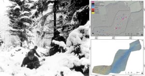
Archeologists using a drone equipped with high-resolution LiDAR have revealed thousands of previously unknown details from the U.S.' largest and bloodiest World War II battle.
Archeologists using a drone equipped with high-resolution LiDAR have revealed thousands of previously unknown details from the U.S.' largest and bloodiest World War II battle.

Last week, we and many others ran the story of a rather astounding collection of photographs that were supposedly discovered in a foxhole where the infamous Battle of the Bulge took place.
Allegedly found by U.S. Navy Captain Mark Anderson and accompanying historian Jean Muller, the story goes that the duo found then scanned the images in an old camera, presenting them to the world seventy years after they were captured and left behind by a soldier who had been KIA. But that, it seems, is not the truth.
Update: Turns out this story was a hoax. Head on over to our update and apology to catch up on the latest.
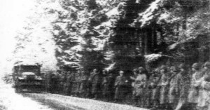
The Battle of the Bulge is known as one of the most deadly and influential battles of WWII. Taking place over the course of five weeks, this surprise attack by the Germans caught allied forces off-guard, causing massive casualties, especially among U.S. Troops.
Among the 89,000 casualties was a soldier named Louis J. Archambeau, a Chicago native who left behind an interesting surprise in a foxhole he had been taking refuge in during the cold weather and rough artillery fire.