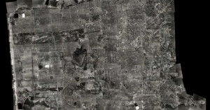
This Zoomable Composite Aerial Photo of San Francisco is Like a 1938 Google Earth
What you see above is an ultra-high resolution aerial photograph of San Francisco as it looked in 1938. The David Rumsey Historical Map Collection put the image together using 164 large format black-and-white photos of SF that were shot in 1938. When viewed through a zoomable image viewer, the composite photo is pretty much a 1938 version of Google Earth's satellite view.