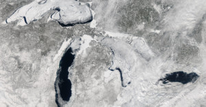
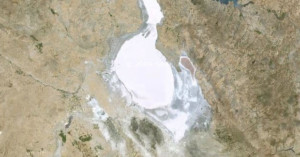
Beautiful NASA Satellite Photo of the Great Lakes Over 80% Covered in Ice
Taken on February 19th (and available in high-resolution here) the satellite image above …
Taken on February 19th (and available in high-resolution here) the satellite image above …
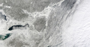
The last couple of days have seen the east coast battered by a huge blizzard known as winter storm Hercules. Thousands of flights have been grounded and many schools were closed yesterday as entire cities began digging themselves out of snowfall that ranged from just a few inches to almost two feet in some areas.
Of course, being there is the only way to truly experience and understand the magnitude of the storm, but this satellite image gives us a small inkling by capturing the blanket of white Hercules left in its wake.
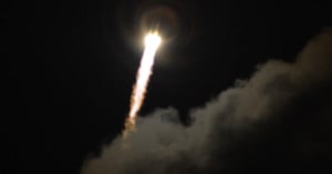
You think 41 megapixels is a lot? Try 1000 megapixels! That's how much resolution the camera attached to the ESA's Gaia satellite is packing; a satellite that, as of yesterday, has left the Earth in its quest to photograph things that have never been photographed before at a resolution as of yet unheard of in space photography.
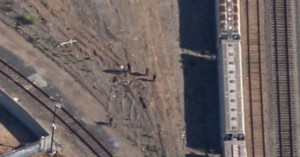
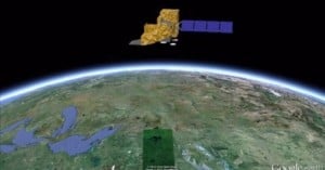
Google has agreed to replace a Google Maps satellite image of a Richmond, California railroad yard that may show the body of a murdered teenager.
After almost ten and a half years of faithful service, the National Oceanic and Atmospheric Administration's (NOAA) GOES-12 satellite was decommissioned last week. And in order to honor the weather satellite for over a decade of providing quality imagery, the NOAA decided to put together a time-lapse showing just how much data the satellite captured in the 3,788 days it was functional.
Want to see how our planet "breathes"? Data visualization guru and cartographer John Nelson recently downloaded twelve cloud-free satellite photograph mosaics of Earth showing what our planet looks like in each month of the year. He then combined them into animated GIFs that show the steady pulse of seasons.
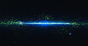
High-resolution photography is seemingly where it's at in today's day and age. NASA knows this, and as such, astrophysicists at both the Goddard Space Flight Center (GSFC) in Maryland and Pennsylvania State University have stitched together a remarkable 160-megapixel UV image of the Large and Small Magellanic Clouds -- our two closest neighboring galaxies (less than 200,000 light years away).
After Moore, Oklahoma was struck by a deadly tornado earlier this week, photographs quickly emerged showing what the storm looked like from space and what the destruction was like on the ground.
Now, Google's Crisis Center website has published satellite photographs showing what the city look like before and after the tornado. As you can see from the "after" photo above, the tornado -- which measured 1.3-miles wide at one point -- left a trail of devastation that looks like a scar on the face of the Earth.
NASA has today released a series of images along with a video following Monday's devastating thunderstorms that produced an F-4 tornado (winds between 166 and 200 miles per hour) that touched down in Moore, Oklahoma. Several satellites were used to provide forecasters with the latest imagery.
NASA's Aqua satellite was responsible for a visible-light image which provided a high-resolution look at the storm. The NOAA GOES-13 satellite provided images of the storm every 15 minutes, and the NASA/NOAA Suomi National Polar-orbiting Partnership satellite observed lightning from the system.
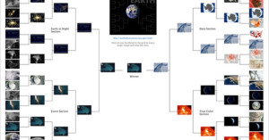
March Madness 2013 came to a thrilling end yesterday with Louisville beating Michigan in the college men's basketball national championship game. Another (less publicized) tournament selected a winner as well: NASA's first ever photo tournament. No, it wasn't a contest in which photographers submit their best image. Instead, Earth 2013 was a tourney that pitted 32 of NASA's photos of Earth against each other in a March Madness-style tourney.

You've probably heard of The Blue Marble, an iconic photo of Earth captured in 1972 from 28,000 miles away by astronauts on the Apollo 17 spacecraft. Well, NASA has just released a number of photographs titled "Black Marble." They offer the same perspective as the iconic photo, except these new images show what our planet looks like at night!
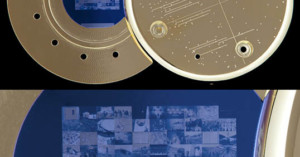
You know those digital photos you've archived by burning onto DVDs and sticking under your bed? You'll be lucky if the files are still readable by the end of your life. Photographer Trevor Paglen wants to archive photos for a much longer time... and by "much longer", we mean billions of years. He's not just doing this for himself, either, but for all of humanity.
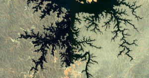
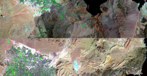
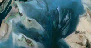
Fractal-like patterns are found widely in nature, "in phenomena including clouds, river networks, geologic fault lines, mountains, coastlines, animal coloration, snow flakes, crystals blood vessel branching, ocean waves and many others." The fact that it appears on a large scale in geographical formations means that many of these beautiful patterns can be captured as photographs from space.
Paul Bourke, a professor at the University of Western Australia, has a webpage dedicated to Google Earth satellite photos that contain these patterns.
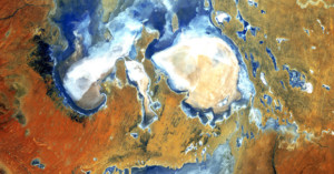
Satellite photographs of Earth are often abstract and artsy, filled with strange colors, shapes, and textures. Some resemble the paintings of old masters, while others look like microscopic slides studied in biology classes. NASA's LandSat has snapped images from space for 40 years now, with many of the images going into a special collection by the U.S. Geological Survey called "Earth as Art". NASA recently decided to run a photo beauty contest to find out which of the satellite images in its collection are the most artistic.
Over 14,000 people ended up voting on the collection of 120+ images. The image above came in at number 5. It's titled "Lake Eyre Landsat 5 Acquired 8/5/2006".
Yesterday marked the 40th anniversary of Landsat, the longest-running program focused on acquiring satellite photos of Earth. The Landsat satellite snaps one completely photo of the Earth's surface every 16 days, and the petabytes of photos collected over the years have given scientists a view into how our planet's surface has changed over time, whether by natural or human-caused means. Google is currently working to make the photos easily enjoyable by the general public by transforming them into time-lapse videos.
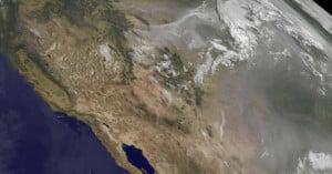
Massive wildfires in the Rockies have destroyed hundreds of homes and scorched tens of thousands of acres over the …
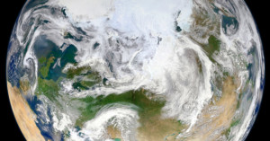
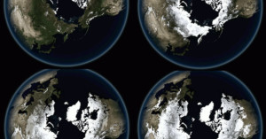
We've seen 'Blue Marble' photos of Earth before, but this latest NASA photo is different: it's the first photo of its kind shot from above our planet's North Pole. The photo is a composite of images captured by a satellite as it passed over the North Pole 15 times at an altitude of 512 miles.
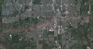
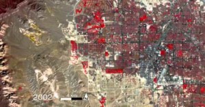
2008 marked the first time in history that more of Earth's population lived in cities rather than in the countryside, and by 2050 nearly 70% of the world's population will reside in large cities. A new series of satellite photographs captured decades apart by NASA's Landsat department and the U.S. Geological Survey offers a striking look at how human cities have spread across the face of the Earth in just a few short years. The image above shows Las Vegas in 1984 and in 2011.
NASA has released a gigantic catalog of …
If you've always wanted to be an astronaut photographer shooting images of Earth from a window of the International Space Station, Stratocam is an app for you. Created by Paul Rademacher, it allows you to snap your own photographs inside Google Maps' satellite view of our planet. You can also view and rate other people's photos, and browse the highest rated images from around the world.
Want to see how Las Vegas has grown from 1972 through 2010? NASA created this unique time-lapse video using …
After NASA published its latest jaw-dropping "Blue Marble" photograph of Earth last month, many of you wondered how "real" the image was. Here's NASA's explanation on how their images are created:
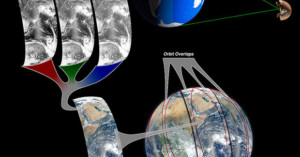
The Suomi NPP satellite is in a polar orbit around Earth at an altitude of 512 miles (about 824 kilometers), but the perspective of the new Eastern hemisphere 'Blue Marble' is from 7,918 miles (about 12,743 kilometers). NASA scientist Norman Kuring managed to 'step back' from Earth to get the big picture by combining data from six different orbits of the Suomi NPP satellite. Or putting it a different way, the satellite flew above this area of Earth six times over an eight hour time period. Norman took those six sets of data and combined them into one image.
So rather than being a composite of multiple images captured from the same perspective, they do in fact map images captured by the satellite onto a 3D sphere.
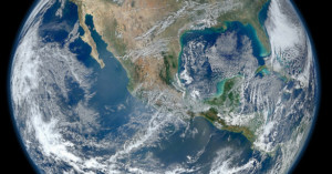
NASA has released another Blue Marble photograph of Earth. It calls this one the “most amazing, highest resolution image …
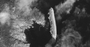
Here’s a satellite photograph showing what the Costa Concordia disaster looks like from …
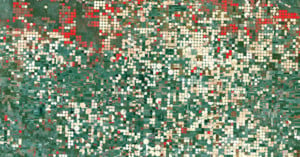
Farmlands might look pretty ordinary from ground level, but photograph crop fields from space (or even from an airplane) and you'll see strange and beautiful patterns.

Ever wonder how the US government managed to capture spy photos with satellites during the Cold War without the …
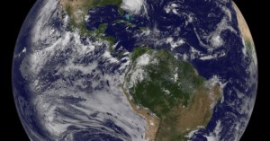
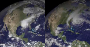
As Hurricane Irene bears down on the East Coast, NASA has published …
Don’t want people using photos of your private island without permission? Watermark it! Billionaire …
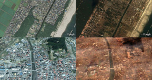
Here’s a Picasa gallery showing Google satellite imagery of various locations in Japan …
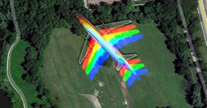
Apparently airplanes travel a little too fast for the satellites that provide photos for Google Maps. It happened to …
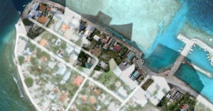
Frank Taylor, the guy behind the unofficial Google Earth Blog, is currently on a 5 years sailing trip around the world called The Tahina Expedition. Google is actually a partner in the expedition, and is acquiring content generated by the trip for use in their products. One thing Taylor has been doing is taking aerial photographs of locations using a kite, resulting in imagery that's much clearer than the photos Google gets from their satellites up in space. Google has already begun incorporating some of these images into their products, as you can see from this Google Maps satellite view of Manihi in French Polynesia.
Check out this Picasa album to see behind-the-scenes photos of Frank setting up his kite and shooting photos.
This has got to be one of the saddest uses of imagery ever. The Daily Mail …
Typical sized white balance cards may be of (literally) little assistance in color calibrating global imaging satellites, …