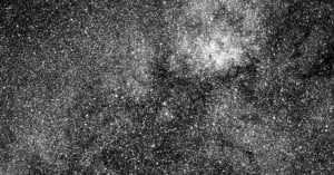
NASA’s New Planet Hunter Snaps First Photo — One With 200,000+ Stars
NASA's newest planet-hunting satellite has captured its first photograph -- a dazzling one that shows over 200,000 stars.
NASA's newest planet-hunting satellite has captured its first photograph -- a dazzling one that shows over 200,000 stars.
Satellite photos are generally shot straight down at the Earth and make the world look like flat, detailed maps. But shoot satellite photos at an angle, and suddenly they look like aerial photos captured from impossible heights with the world's longest telephoto lens.
Photographer Páraic McGloughlin took Google Earth satellite photos and strung them together into this extremely fast-paced animation titled Arena. The lines and shapes seen from a bird's-eye view are used to create movement in the frame.

Yesterday, we shared what a total solar eclipse looks like to a weather balloon floating in near space. If you want to zoom out even more, check out this amazing video captured by a weather satellite from outer space.

Aboard NASA’s Aqua satellite, the MODIS captures imagery of the Earth’s water bodies. On May 29, it captured the data used to create this mesmerising image of phytoplankton blooming in the Black Sea.
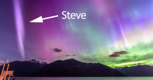
Aurora photographers have been buzzing in recent days about a newly spotted phenomenon in the sky. It's a purple ribbon of light that differs in appearance from standard aurora. After being confirmed as a new phenomenon, it was given a new name: "Steve."

NASA has just released a new set of composite satellite photos showing what Earth looks like at night. The gorgeous images feature glowing lights across the planet showing where civilization is found.

1 terapixel equals 1 million megapixels, or 1 trillion pixels. And San Francisco-based satellite startup Planet plans to capture 50 of these terapixels each day starting later this year. Specifically, they plan to capture one 50 terapixel image of our entire planet every single day.
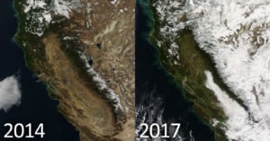
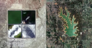
After years of serious drought, California appears to be on the road to recovery. The state experienced its driest years on record between 2011 and 2014, but rains and snow have brought new life to the region since then, and this can be seen in NASA's satellite photos.
NASA has a new high resolution toy in orbit. The GOES-16 weather satellite was launched from Cape Canaveral back in November, and NASA just published the first photos of our Earth taken by this new satellite and its special "Advanced Baseline Imager."

Google Earth Timelapse lets you experience the changing face of our planet like nothing else out there—you can watch glaciers move, forests grow, and cities expand. Today, that incredible tool got a massive update.

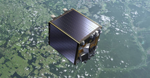
Canon is planning to launch a miniature satellite into orbit, and onboard will be a space camera that's based on the Canon 5D DSLR.

This week, a fire at Puerto Rico's largest power plant triggered a chain reaction that has left the majority of the country without power, air conditioning, and water. These satellite images show what it looks like when 1.5 million homes lose power all at once.
NASA just released a timelapse video that will give you an eye-opening dose of perspective. The 3-minute video above shows 1 year in the life of Earth, photographed from 1 million miles away.
If your mantra in life is "bigger is better," then here's a lens for you. Over in Ukraine, someone is selling a gigantic lens from a Soviet spy satellite on the country's "craigslist".

Planetary Resources, the company behind the ARKYD Kickstarter that promised you the chance to take a 'space selfie' for just $25, announced today that it is cancelling the project and will refund all $1.5 million raised in 2013.
NASA just gave satellite imagery nerds a very big present: along with a bunch of other scientific data, the space agency just made 2.95 million images of Earth changing surface available to the public at no cost.
During the total solar eclipse on March 8th and 9th, NASA had a camera documenting it from a very special perspective -- one that's 1 million miles away.
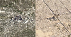
The Jefferson Grid is a new Instagram account that's attracting quite a bit of attention. Each photo posted is a satellite photo of some place in the United States that was discovered using Google Earth. Each photo also shows the area of exactly one square mile.
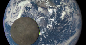
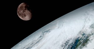
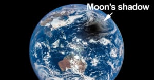
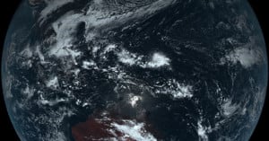
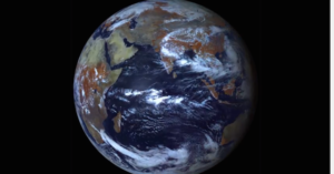
Last month, NASA shared the first full photo of Earth captured with its new DSCOVR camera that's floating 1 million miles away. Today it released another amazing series of shots, with this one showing the moon floating across the face of the Earth. The 20-second video above strings a number of the pictures together.

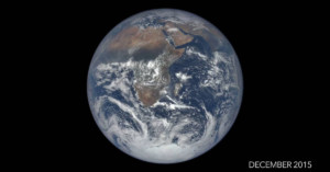
NASA's new Deep Space Climate Observatory Satellite (DSCOVR) has captured its first photo (shown above) of our planet from one million miles away. By comparison, the similar and iconic Blue Marble photo captured by the crew of the Apollo 17 was just 28,000 miles away when that picture was snapped in 1972.

Since late 2014, Japan's Himawari 8 weather satellite has been in stationary orbit above New Guinea, 22,000 miles out (Earth's average diameter is 7,918 miles). It shoots one photo of Earth every 10 minutes, capturing 144 pictures of our planet over the course of a day.
When combined, the photos form a gorgeous time-lapse video showing the passing of a day on Earth. In the 20-second video above, the Sun's reflection can be seen in the daylight that moves across the surface of the globe.
A camera used on satellites to monitor vegetation from space may soon help save lives in the battle against cancer. The special camera will be capable of peering into human skin to see things that are invisible to the naked eye for the purpose of detecting diseases early.
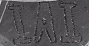
This past week, 300 employees at Israel Aerospace Industries (IAI) posed for an unusual group picture to mark Israeli Space Week. They arranged themselves in the shape of giant letters to spell out "IAI" and posed as a satellite camera snapped the shot (shown above).

Artist INSA is known for creating mesmerizing animated GIFs using street art and photos. He was recently recruited by the scotch whisky brand Ballantines to create "the world's largest animated GIF," one that was created with gigantic paintings on the ground and photos from a satellite camera.

What you see above is the first satellite photo of the contiguous 48 states of the United States. It …
The Japan Meteorological Agency launched its latest weather satellite called the Himawari 8 …
Aerial Wallpapers is a website filled with beautiful wallpapers for your mobile device. Each of the images is a 1242×2208 pixel crop of a beautiful satellite photograph.
The project is curated by João Paulo Bernardes, who searches through the Creative Commons archives of NASA and the Airbus Defense and Space.

Every 30 minutes, the weather satellite Elektro-L captures a 121 megapixel image from geosynchronous orbit using both visible and infrared light. And it's these images, captured between May 15th to May 19th, 2011, that James Tyrwhitt-Drake compiled into an incredibly beautiful, high-res time-lapses of the Blue Marble.

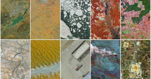
Earth can be absolutely beautiful as seen from the ground. But, as wonderful as it is from our point of view, certain scenes just can’t be appreciated unless seen from a bird’s eye view.
It’s this idea that lead satellite imaging company Digital Globe to create Daily Overview, a daily blog that aims to capture the beauty of landscapes and structures as seen from overhead.
Over the past 24 hours, the Earth has been experiencing its autumnal equinox. That is, the length of day and night across the globe was the same due to the sun hitting the earth at just the right angle to align its shade perfectly with the Earth’s spin axis.
And thanks to the photographic work of Russian satellite Elektro-L, we get an awesome (albeit quick) view of this bi-annual occurrence from a pretty spectacular vantage point: space.
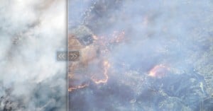
DigitalGlobe really wants people to get behind their super-high res public imaging satellite, the WorldView-3, and understand just how useful it could be. To that end, they're showing off the satellite's capabilities once again, this time using the onboard infrared sensor to see beneath the smoke of a California forest fire and capture some incredibly detailed images of the inferno.
Cue privacy overreaction in three... two... one...
Remember DigitalGlobe's WorldView-3, the first high-res public imaging satellite we told you about earlier this month? Well, it's up in orbit, and the company wants to show off just how capable the WorldView-3 really is.

A Belgian company called SpaceBooth is planning to launch its own little -- and we mean really little -- satellite photo both before 2015. Its mission? To give you the chance to have your photo taken with the Earth, Moon or stars as the backdrop... for free.

A month ago, the US Government lifted restrictions on high-detail satellite images. Previously, these restrictions prohibited the capture of anything under 1.64 feet in size; now that they're gone, a number of companies are anxious to launch their latest and greatest satellites and bring high res satellite imagery to the public for the very first time.
And the first to finish line is Lockheed Martin, whose DigitalGlobe‘s high-res WorldView-3 satellite is set to take off in August.

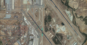
Airports are a common source of creative and interesting imagery. From time-lapses of the comings and goings to composites that pack hours worth of departures into a single image, the sheer scope and complexity of airports fascinates many creatives.
One such creative is Art Director Lauren O'Neill, whose photo series/Tumblog Holding Pattern reveals the intricacies of airports from above using Google Earth satellite imagery.
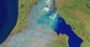
When it comes to natural disasters like hurricanes or wildfires, not even standard aerial photography can really cut it. To capture something that occurs on such a massive scale, you need a massive view, and so these disasters are often best visualized by NASA's satellites.

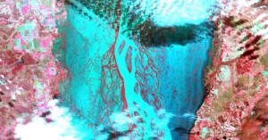
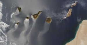
Taken by a collection of three satellites orbiting Earth -- Landsat 7, ASTER, and MODIS -- the images above and below are part of an incredible collection of photos that were captured from space purely for their aesthetic beauty, rather than the usual scientific reasoning.
If you're more into satellite photography than basketball, then March probably had you following along with an entirely different tournament than most of the US: NASA's Tournament Earth 2014. Instead of pitting teams against each other, this tournament packed a bracket full of satellite imagery until a clear winner emerged.

Today is the spring equinox -- one of the two days during the year when night is almost exactly equal to day -- and in good ol' fashioned APOD style, the folks at NASA are helping us understand and visualize this phenomenon by zooming out... waaaaay out.