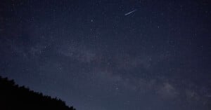
The Meteors, Asteroids, and Planets You Can Photograph in December
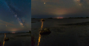
NASA has shared its monthly update for what skygazers should look for in the night sky in December.
NASA has shared its monthly update for what skygazers should look for in the night sky in December.
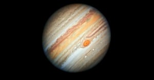
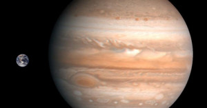
On September 26, Jupiter will be closer to Earth than it has come in the last 59 years which combines with the gas giant's opposition, which should result in spectacular views.
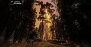
National Geographic's May 2022 issue is focused entirely on trees, critically endangered forests, their importance to the planet, and the need to preserve them.
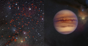
In a groundbreaking discovery, astronomers have spotted at least 70 -- but potentially up to 170 -- new "rogue" planets floating by themselves in space thanks to wide-field images gathered from satellites and other facilities across the globe.
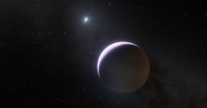
The European Southern Observatory's (ESO) Very Large Telescope (VLT) has captured a photo of a planet orbiting b Centauri, which challenges many previous theories regarding massive stars and their ability to host planets.
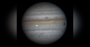
Something massive slammed into Jupiter this week, and a Brazilian amateur astronomer had his camera aimed at the gas giant at just the right time to capture the event.
French astrophotographer Jean-Luc Dauvergne has published what he claims is the best global map of Mars ever shot from the surface of Earth. This 2-minute video shows both the map and a rotating view of Mars created with the same images.
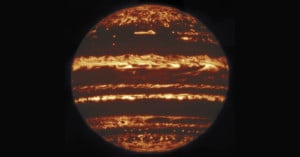
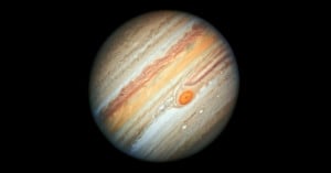
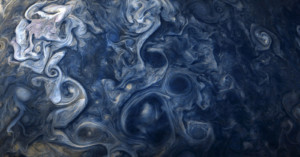
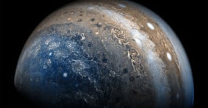
Scientists have created the highest-resolution photos of Jupiter ever captured from the ground, including this gorgeous infrared photo created by stacking a large number of exposures.
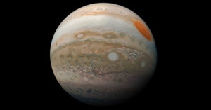
The Hubble Space Telescope has captured a new portrait of Jupiter that shows the gas giant's details, including the Great Red Spot, in a more intense color palette than in the past.
Jupiter is usually shown with its cloud layers running horizontally across the face of the gas giant. NASA has released new photos from its JunoCam showing full-disc views of Jupiter from uncommon angles.
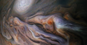
NASA just released this new close-up photo of the swirling clouds found on Jupiter. It was captured by the Juno spacecraft on October 29th, 2018, during its 16th close flyby of the gas giant.
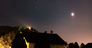
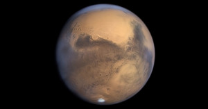
Mars is brighter than it has been for 15 years this month, and it's so bright that you can shoot its reflection in the ocean. Felix Jäger of Austria shot this 30-second timelapse showing the uber-bright red planet rising into the sky from behind his house.
Mars is closer to Earth and brighter than its been since back in 2003. It's so bright that photographer Abdul Dremali managed to capture this photo of the planet casting a bright reflection on the ocean as it rose into the night sky.
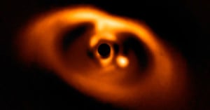
Behold: this is the first confirmed image of a planet being born. The image was captured by SPHERE, a planet-hunting instrument on the European Southern Observatory's (ESO) Very Large Telescope.
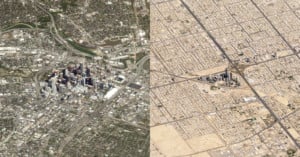
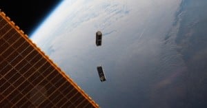
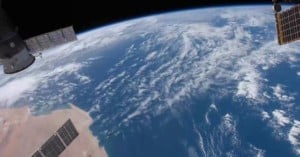
Satellite photos are generally shot straight down at the Earth and make the world look like flat, detailed maps. But shoot satellite photos at an angle, and suddenly they look like aerial photos captured from impossible heights with the world's longest telephoto lens.
NASA's Juno space probe has been orbiting Jupiter and dazzling us with photos of the giant gas planet for over a year now. In recent days, Juno has captured a number of gorgeous close-up photos that look strangely like impressionist art.
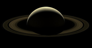
On September 15, 2017, NASA's Cassini space probe plunged into Saturn's atmosphere and burned up, concluding its mission after 13 years in orbit. Two days earlier, Cassini used its wide-angle cameras and captured this beautiful final photo of the planet it had studied for over a decade.
Every 53 days, NASA's Juno spacecraft flies close to Jupiter and travels from the giant gas planet's north pole to and past its south pole, shooting photos along the way. The eye-opening 2-minute video above was created using a set of these still photos.
1 terapixel equals 1 million megapixels, or 1 trillion pixels. And San Francisco-based satellite startup Planet plans to capture 50 of these terapixels each day starting later this year. Specifically, they plan to capture one 50 terapixel image of our entire planet every single day.
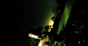
Instead of capturing a night sky time-lapse with the stars spinning overhead, Windston attached a GoPro HERO4 to his star-tracking telescope rig and shot the 1-minute video above that show's Earth's rotation in a different way.
NASA just released a timelapse video that will give you an eye-opening dose of perspective. The 3-minute video above shows 1 year in the life of Earth, photographed from 1 million miles away.
Forget the dark side of the moon (except the album... never forget that album), this photograph released last week by NASA shows you the dark side of a different celestial body: Pluto.
Geotagging is usually done using a built-in GPS system, but in the future it might be possible to figure out where a photo was shot just by showing the picture to an artificial intelligence program.

When you think of the planet Jupiter, you probably think of that giant striped planet with the Great Red Spot anticyclonic storm swirling across the face. But that's just one way of looking at Jupiter.
The photo above, created with images from NASA's Cassini space probe, shows what Jupiter looks like from directly above the north pole.
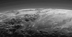
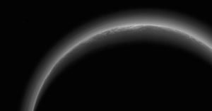
NASA has released a spectacular new photo of Pluto that was captured by its New Horizons spacecraft during the flyby on July 14th, 2015. This latest one shows a near-sunset view of the icy mountains on Pluto surface, poking up on a curved horizon.
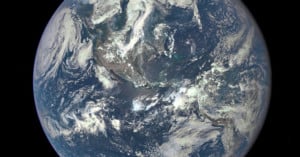
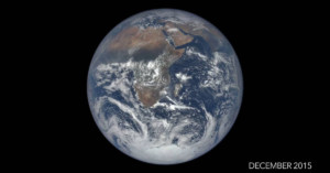
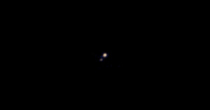
NASA's new Deep Space Climate Observatory Satellite (DSCOVR) has captured its first photo (shown above) of our planet from one million miles away. By comparison, the similar and iconic Blue Marble photo captured by the crew of the Apollo 17 was just 28,000 miles away when that picture was snapped in 1972.
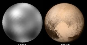
Pluto was first discovered on February 18, 1930, by a 23-year-old man named Clyde Tombaugh, who compared photos captured 6 days apart and discovered the dwarf planet moving between the two shots. Since then, scientists have created numerous photos of Pluto over the years, but none clearer than the ones NASA made over the past week with the New Horizons space probe.
Here's a look at how mankind's view of Pluto has gotten sharper over the years as we've pointed better (and closer) cameras at it.
Since late 2014, Japan's Himawari 8 weather satellite has been in stationary orbit above New Guinea, 22,000 miles out (Earth's average diameter is 7,918 miles). It shoots one photo of Earth every 10 minutes, capturing 144 pictures of our planet over the course of a day.
When combined, the photos form a gorgeous time-lapse video showing the passing of a day on Earth. In the 20-second video above, the Sun's reflection can be seen in the daylight that moves across the surface of the globe.
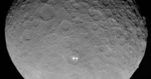
This is the closest photo ever shot of the dwarf planet Ceres, the largest object in the asteroid belt. It was captured on May 4th by NASA's Dawn spacecraft while orbiting from 8,400 miles away.

NASA’s Curiosity rover on Mars recently captured this surprisingly artistic photograph of a Martian sunset. Mountains in the horizon …
After a nine year journey towards the outer edge of our solar system, NASA's New Horizons spacecraft has beamed back its first color photo of Pluto and its largest moon Charon. The photo above, captured "just" 71 million miles away from the dwarf planet, is the closest color photo ever made of Pluto.
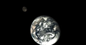
Check out this amazing photograph of our planet with the Moon hovering in the background. It was published today by China's State Administration of Science, and was captured by the country's Chang'e 5-T1 spacecraft that did a flyby of the moon late last month.
Pluto has had a rough existence. Discovered February 18th, 1930, the largest object in the Kuiper belt has gone through a number of classifications, eventually settling on "dwarf planet" at this point in time.
The interesting thing is, as much as we may know about this dwarf planet, we don’t have a very good idea of what it looks like. Scientists have yet to take a clear photograph of Pluto, but around this time next year (on July 14th, 2015, to be exact) that'll change.
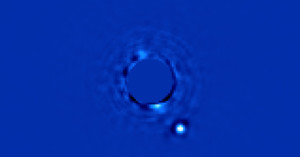
Although it might not seem like much, the photo above might just be the most extraordinary image you have ever seen. Not because of crazy high megapixel count or amazing composition or even subject matter -- we've seen images of planets orbiting stars before -- but because it is the first ever image of a planet and its star over 63 light years away.
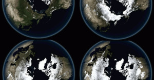
Want to see how our planet "breathes"? Data visualization guru and cartographer John Nelson recently downloaded twelve cloud-free satellite photograph mosaics of Earth showing what our planet looks like in each month of the year. He then combined them into animated GIFs that show the steady pulse of seasons.
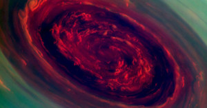
Photographs of storm systems as seen from airplanes or satellites aren't too uncommon these days, but have you ever seen one that looks like this? Probably not, because this photograph is out of this world -- literally. It's titled "The Rose," and shows the spinning vortex of a gigantic hurricane on the surface of Saturn.

You've probably heard of The Blue Marble, an iconic photo of Earth captured in 1972 from 28,000 miles away by astronauts on the Apollo 17 spacecraft. Well, NASA has just released a number of photographs titled "Black Marble." They offer the same perspective as the iconic photo, except these new images show what our planet looks like at night!
An apparent meteor struck Jupiter yesterday, creating an explosion so massive that amateur astronomers looking through their telescopes her on Earth were able to see it. Amateur astrophotographer George Hall of Dallas, Texas happened to have a camera and telescope pointed at the planet at the time, and managed to snag some video footage of the fireball, which he soon uploaded to his Flickr account.
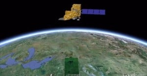
Yesterday marked the 40th anniversary of Landsat, the longest-running program focused on acquiring satellite photos of Earth. The Landsat satellite snaps one completely photo of the Earth's surface every 16 days, and the petabytes of photos collected over the years have given scientists a view into how our planet's surface has changed over time, whether by natural or human-caused means. Google is currently working to make the photos easily enjoyable by the general public by transforming them into time-lapse videos.
18-year-old photography enthusiast Tomislav Safundžić of Croatia gathered some …