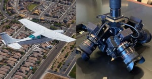
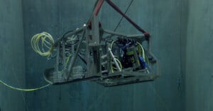
mapping

How an Aerial Mapping Company Uses Four Sony a7R IVs

AerialSphere is a Phoenix-based aerial mapping company that provides 360 degree imaging built for 3D software. “Our mission is to take the blinders off traditional mapping technology and allow our clients to see the world in 360° clarity.”

Mapillary is Building a Crowdsourced Street View with User Submitted Photos

Google's well-known Street View service is one of several monumental efforts to document the world's travel routes through ground-level photos. These projects generally use fancy camera rigs on cars, backpacks, and even camels to capture their images.

Mapillary is a startup that's trying to do things a little differently. Instead of taking the grunt work of photo-taking upon itself, the service is building a crowdsourced Street View competitor using photos submitted by users.

Matterport Captures Amazing 3D Interiors Using Special Camera

Founded in 2011, interior mapping startup Matterport is planning to bring detailed 3D mapping to your home, office and beyond very soon. Using a special camera rig designed by Matterport co-founder Matt Bell, the system promises to help users "create accurate, photo-realistic 3D models -- quickly, easily and automatically."

Google Adding User-Created Balloon and Kite Imagery to Google Earth

Innovation is why we love companies like Google. Several times a week, it seems, the company comes out with another program or product idea that makes us all smile (and secretly wonder how long we have until they've achieved world domination). Their best ideas, however, involve their user base -- and their latest expansion idea for Google Earth does just that.