Location Recognition for Photographs by Looking at Architecture
Cameras these days are smart enough to recognize the faces found inside photographs and label them with names. What if the same kind of recognition could be done for the locations of photographs? What if, instead of using satellite geodata, the camera could simply recognize where it is by the contents of the photographs?
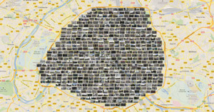
That's what research being done at Carnegie Mellon University and INRIA/Ecole Normale Supérieure in Paris may one day lead to. A group of researchers have created a computer program that can identify the distinctive architectural elements of major cities by processing street-level photos.