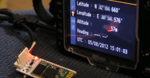
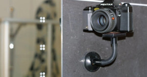
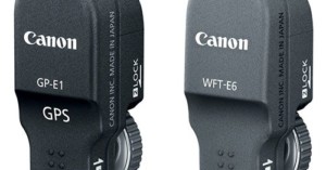
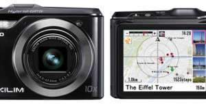
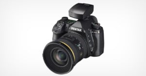
Posts Tagged ‘gps’

Photos of Locations Where Geotagged Tweets Were Sent

Photos of Locations Where Geotagged Tweets Were Sent Creeper

The photograph above shows the location where the following Tweet was posted:

Love hiding in the back at work because I have a 35 year old creeper. #scared #help

It’s one of the photos in a project titled Geolocation: tributes to the Data stream, by photographers Nate Larson and Marni Shindelman. Each image in the series shows the location were a particular geotagged Twitter Tweet was posted.
Read more…

Geotagged iPhone Photograph Leads to Fugitive Software Tycoon’s Downfall

Geotagged iPhone Photograph Leads to Fugitive Software Tycoons Downfall mcafee

The saga of anti-virus pioneer John McAfee’s run from the law is a strange one, but this much is clear: McAfee wishes geotagging wasn’t a feature built into modern cameras. After a month of fleeing from Belizean law enforcement after a neighbor was found murdered, the software tycoon was finally taken into custody this week, largely due to a single photo loaded with GPS data.
Read more…

Build a DIY Bluetooth GPS Unit for Your Nikon DSLR

Build a DIY Bluetooth GPS Unit for Your Nikon DSLR gps mini

Israeli photographer Ido Nassimi wanted to geotag the photographs shot using his Nikon D90, but didn’t want to shell out $200 bucks for Nikon’s official GP-1 GPS receiver. Since he had a GPS Bluetooth receiver lying around, he decided to do some research and make it compatible with his DSLR. He ended up successfully building one for around $50.
Read more…

Why Your Digital Camera’s GPS Might Not Work in China

Why Your Digital Cameras GPS Might Not Work in China badgps mini

It’s strange to think that cartography laws could somehow affect the functionality of your camera overseas, but a recent article on Ogle Earth points out that just such a thing has been going on with GPS-enabled cameras as far back as 2010. The whole “investigation” into the matter began with the release of the Panasonic TS4 earlier this year. For some reason the press release cautioned that the GPS in the camera “may not work in China or in the border regions of countries neighboring China.”

But after doing some digging they discovered that these restrictions are not limited to the TS4, nor are they even limited to Panasonic. In fact, many major manufacturers go to great lengths to conceal or toss away the location data captured by GPS-enabled cameras when you’re taking photos in the People’s Republic of China. Read more…

Canon Patents Imprecise EXIF Data for Shooters Concerned with Privacy

Canon Patents Imprecise EXIF Data for Shooters Concerned with Privacy exif mini

9 out of 10 adults in America believe that people are over-sharing sensitive personal information. One culprit is the GPS-enabled camera, which can reveal exactly where you were at a specific time by baking the information into photos. If you’re uncomfortable with how specific this EXIF data is, Canon has a solution: fuzzy precision. The company has patented a system that may one day allow its camera users to choose “low precision” EXIF data. This means cameras would record rough and non-specific details of when and where an image was made. Instead of 12:31pm, it might record it was 12-1pm, and instead of a particular location, it might provide a general area on a map.

(via Egami via Canon Watch)

Turn an Old GPS or Cell Phone Mount Into a Suction Cup Tripod

Turn an Old GPS or Cell Phone Mount Into a Suction Cup Tripod suction mini

If you have an old mount for attaching a GPS or cell phone to your windshield, you can upcycle it into a suction cup tripod for your camera (just make sure it’s not the flimsy kind that falls off on its own). What you’ll need to do is flatten the mount surface and then install a tripod screw. Nano_Burger has a step-by-step tutorial on how he did this conversion over on Instructables. The resulting tripod allows you to fix your camera in locations that aren’t accessible to tripods that don’t suck (hah, get it?).

Turn Your GPS Suction Cup Support Into A Camera Tripod (via Lifehacker)

Canon 1D X Has Optional (and Pricey) Wi-Fi and GPS Add-ons

Canon 1D X Has Optional (and Pricey) Wi Fi and GPS Add ons gpswifi mini

Remember the network and Wi-Fi icons in the Canon patent we shared yesterday? Well, they both appeared today in the Canon 1D X announcement, but only one of them is built in. The new DSLR offers a built-in gigabit Ethernet jack for ultra-fast data transfers, but wireless transfers will require an additional add-on: the WFT-E6A Wireless File Transmitter. It’s designed exclusively for the new camera, and supports Bluetooth in addition to Wi-Fi. Priced at $600, it costs as much as an entry level DSLR.

There will also be a Canon GP-E1 GPS Receiver add-on for logging location data and camera direction. It’ll have a retail price of $300 when it’s released alongside the camera in March 2012.


In other news, Canon has passed the 70 million mark for EF lenses produced, while Nikon has just produced its 65 millionth SLR lens.

Flickr Beefs Up Privacy with “Geofences”

Flickr Beefs Up Privacy with Geofences geofence1 mini

Flickr introduced an innovative location-based privacy feature today called “geofences“. It’s a way of assigning default privacy settings to certain locations for geotagged photographs. For example, you can assign a geofence with a certain radius around your home, and automatically set those photos’ location data to only be visible to your friends and family. Each user can have up to 10 geofences, and existing photographs are automatically updated to new geofence privacy settings.

Satellite Photographs Being Used to Cheat at Corn Mazes

Satellite Photographs Being Used to Cheat at Corn Mazes cornmaze

This has got to be one of the saddest uses of imagery ever. The Daily Mail is reporting that iPhone owners in the UK are using satellite photos and GPS to cheat at getting out of corn mazes. By seeing their current location in a birds-eye view of the maze, visitors can quickly solve even the most challenging corn mazes.

Adventure seekers usually spend anything up to 90 minutes getting lost in the Hedge Maze at Longleat Safari Park, Wiltshire, before finding the exit.

But staff at the attraction have noticed people are working their way round the labyrinth of two miles of pathways and 16,000 yew trees in just a matter of minutes.

The idea is clever, but super lame. Can you think of anything else that satellite imagery can help you cheat at?

iPhone cheats crack Britain’s biggest hedge maze in minutes (via Wired)


Image credit: Cheating in the maze by Andrew*

Casio EX-H20G Uses Hybrid GPS System to Track Your Location

Casio EX H20G Uses Hybrid GPS System to Track Your Location exlimgps

Just unveiled at Photokina, Casio’s new EXILIM EX-H20G point-and-shoot is a pretty ordinary 14.1 megapixel HD video-capable camera with a trick up its sleeve: a hybrid GPS system for geotagging your photos. Ordinarily cameras geotag your images with location based on signals from GPS satellites, but become oblivious to where you are if you move to a location where the signals can’t be detected. The EX-H20G attempts to overcome this problem by storing the user’s last known satellite location in the camera’s memory, and then using data from internal motion sensors to calculate where the user has moved to since the signal was lost.

It’s not clear yet how accurate this hybrid system is, or whether the camera needs to stay on for all this to work. If it does indeed work as advertised, then this is a pretty nifty solution to a common problem. The camera will be available in November 2010 for $350.