
Company Uses Drone Photos to Create ‘Google Earth on Steroids’
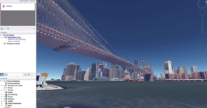
A company that creates interactive aerial images of living environments describes its product as "Google Earth on steroids."
A company that creates interactive aerial images of living environments describes its product as "Google Earth on steroids."
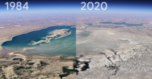
Google has partnered with the CREATE Lab at Carnegie Mellon University to debut the biggest update to the Google Earth platform in years: a timelapse function that shows how much the Earth and its climate have changed between 1984 and 2021.
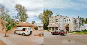
During the COVID-19 pandemic, we have been asked to stay home and shelter in place. This restriction has only increased my desire to explore and road trip. I still need to create and think critically throughout this time, but if I can’t go to new places, how can I make new work?
There are a lot of great location scouting tools out there. But while PhotoPills and The Photographer's Ephemeris do an amazing job and are packed full of useful features, photographer Tony Northrup explains why he prefers to use something else that's completely free: Google Earth.
"Epoch" is a new video by Ireland-based visual artist Kevin McGloughlin. It's a mesmerizing animation that was created over several months entirely out of Google Earth satellite photos.
Photographer Páraic McGloughlin took Google Earth satellite photos and strung them together into this extremely fast-paced animation titled Arena. The lines and shapes seen from a bird's-eye view are used to create movement in the frame.
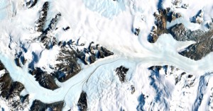
Google Earth Timelapse lets you experience the changing face of our planet like nothing else out there—you can watch glaciers move, forests grow, and cities expand. Today, that incredible tool got a massive update.
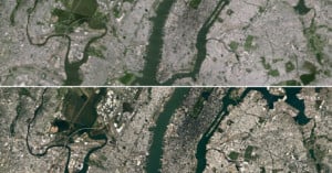
Google Maps and Google Earth just got a whole lot sharper thanks to NASA and its Landsat 8 satellite. Using beautiful high-res imagery captured by the new satellite, Google has built a better high-res cloud-free mosaic of the world based on some 700 trillion pixels of data.
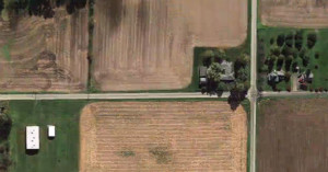
The Jefferson Grid is a new Instagram account that's attracting quite a bit of attention. Each photo posted is a satellite photo of some place in the United States that was discovered using Google Earth. Each photo also shows the area of exactly one square mile.
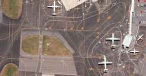
Airports are a common source of creative and interesting imagery. From time-lapses of the comings and goings to composites that pack hours worth of departures into a single image, the sheer scope and complexity of airports fascinates many creatives.
One such creative is Art Director Lauren O'Neill, whose photo series/Tumblog Holding Pattern reveals the intricacies of airports from above using Google Earth satellite imagery.
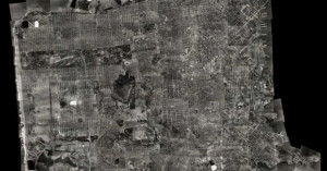
What you see above is an ultra-high resolution aerial photograph of San Francisco as it looked in 1938. The David Rumsey Historical Map Collection put the image together using 164 large format black-and-white photos of SF that were shot in 1938. When viewed through a zoomable image viewer, the composite photo is pretty much a 1938 version of Google Earth's satellite view.
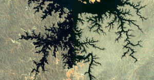
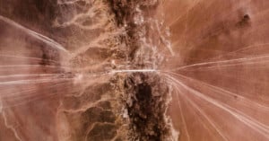
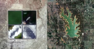
Fractal-like patterns are found widely in nature, "in phenomena including clouds, river networks, geologic fault lines, mountains, coastlines, animal coloration, snow flakes, crystals blood vessel branching, ocean waves and many others." The fact that it appears on a large scale in geographical formations means that many of these beautiful patterns can be captured as photographs from space.
Paul Bourke, a professor at the University of Western Australia, has a webpage dedicated to Google Earth satellite photos that contain these patterns.
Innovation is why we love companies like Google. Several times a week, it seems, the company comes out with another program or product idea that makes us all smile (and secretly wonder how long we have until they've achieved world domination). Their best ideas, however, involve their user base -- and their latest expansion idea for Google Earth does just that.

If you thought Google Earth was cool, check out the work being done by Swedish corp …
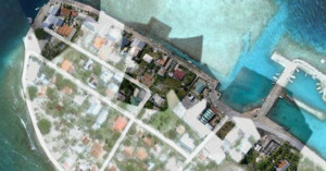
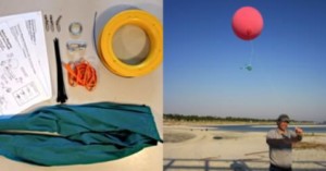
Frank Taylor, the guy behind the unofficial Google Earth Blog, is currently on a 5 years sailing trip around the world called The Tahina Expedition. Google is actually a partner in the expedition, and is acquiring content generated by the trip for use in their products. One thing Taylor has been doing is taking aerial photographs of locations using a kite, resulting in imagery that's much clearer than the photos Google gets from their satellites up in space. Google has already begun incorporating some of these images into their products, as you can see from this Google Maps satellite view of Manihi in French Polynesia.
Check out this Picasa album to see behind-the-scenes photos of Frank setting up his kite and shooting photos.

Google recently added high-quality street level photographs to …