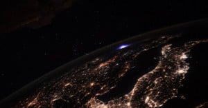
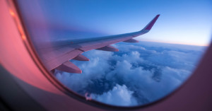
Posts Tagged ‘aerial’

The Invention of the Pigeon Camera for Aerial Photography

The Invention of the Pigeon Camera for Aerial Photography pidgeon1

We’ve featured a couple of projects involving cameras strapped to birds recently (see here and here), but photographing with birds is anything but a new idea. It was actually invented a little over a century ago, in 1907, by a German photography pioneer named Julius Neubronner.
Read more…

Helmet Cam Strapped to Hunting Falcon Captures “Birds-Eye-View” Footage

Helmet Cam Strapped to Hunting Falcon Captures Birds Eye View Footage falcon mini

Have you always dreamed of soaring high above the Earth… and dive-bombing other birds? If so, this might be the next best thing: some falconers over in the UAE capital of Abu Dhabi recently created a pint-sized helmet cam designed specifically for their hunting falcon.
Read more…

Photographer Takes to the Sky After Being Denied Access to Oil Mines

Photographer Takes to the Sky After Being Denied Access to Oil Mines albertasands2 mini

When photographer Robert Johnson of Business Insider was denied so much as a tour of the Alberta Oil Sands, he could have given up. Instead he chose a more… aerial approach, renting a Cessna 172 to secretly photograph the secretive operation from just over 1,000 feet.

The Alberta Oil Sands are the second largest oil deposit in the world behind Saudi Arabia, and some of the pictures, all of which are now up on Flickr, go a long way in showing how huge an operation like this has to be. In fact, it’s a good thing they denied Business Insider access, photos from the ground probably wouldn’t have done the sands nearly as much justice.

The Canadian Oil Sand Mines Refused Us Access, So We Rented This Plane To See What They Were Up To (via Kottke)

Beautiful Photographs of Patterns Seen from a Helicopter

Beautiful Photographs of Patterns Seen from a Helicopter air1 mini

Aerial photographer Stephan Zirwes shoots amazing images of patterns and repetition seen in landscapes while looking straight down from a helicopter. From his perspective, things like cars, shipping containers, and people blend together into abstract designs.
Read more…

Aerial Photographs Showing Patterns and Repetition

Aerial Photographs Showing Patterns and Repetition pat1 mini

Alex MacLean is a Massachusetts-based photographer and pilot who uses his dual interests to create epic aerial photographs.

Alex MacLean has flown his plane over much of the United States documenting the landscape. Trained as an architect, he has portrayed the history and evolution of the land from vast agricultural patterns to city grids, recording changes brought about by human intervention and natural processes. His powerful and descriptive images provide clues to understanding the relationship between the natural and constructed environments.

Read more…

Aerial Interior Photo of a Building Created by Stitching Hundreds of Photos

Aerial Interior Photo of a Building Created by Stitching Hundreds of Photos aerial1 mini

Architectural photographer Brett Beyer was recently commissioned by Cornell University to make a photograph of the interior of its recently completed Milstein Hall. The request wasn’t for a standard interior photo, but for an aerial shot of the 25,000-square-foot studio space that looked as if you were looking down at it with the roof removed (think Google Earth but for the interior of a building). Beyer accomplished this by pointing his Canon 5D Mark II and 17-40mm lens down from the ceiling on a 12-foot boom and then capturing 250 separate photographs of every square inch of the space over three days. He then spent 10 days stitching the images together by hand in Photoshop to create the amazing photo seen above.
Read more…

Shoot, Share, and Explore Satellite Photos of Earth with Stratocam

Shoot, Share, and Explore Satellite Photos of Earth with Stratocam space1 mini

If you’ve always wanted to be an astronaut photographer shooting images of Earth from a window of the International Space Station, Stratocam is an app for you. Created by Paul Rademacher, it allows you to snap your own photographs inside Google Maps’ satellite view of our planet. You can also view and rate other people’s photos, and browse the highest rated images from around the world.
Read more…

Stunning 360° Aerial Panoramas of the World’s Highest Waterfall

Stunning 360° Aerial Panoramas of the World’s Highest Waterfall waterfall1 mini

Angel Falls is the world’s highest waterfall as well as the inspiration for Paradise Falls in the Pixar film Up. Unless you’re planning on visiting the falls in the heart of Venezuela in person, the next best thing might be this stunning series of 360° aerial panoramas recently captured by photographer Dmitry Moiseenko over two days from a helicopter. Pan around, zoom into the scene, and become immersed in the otherworldly landscapes found at Angel Falls.
Read more…

How Photographs of Fighter Jets in Flight Are Captured

Aviation photographer Justin de Reuck has an awesome job: rather than do photo shoots in the comfort of a studio, he hops into fighter jets to photograph other airplanes in flight. This behind-the-scenes video shows him at work, snapping images while zipping around above the clouds and battling G-forces. The photographs that resulted from this shoot can be seen here.

(via Fstoppers)

Japanese Flying Ball Could Be the Future of Aerial Camera Systems

Japan’s Ministry of Defense has unveiled an amazing “Spherical Flying Machine”: a 42-inch remote controlled ball that can zip around in any direction at ~37mph. Built using off-the-shelf parts for about $1,400, in Internet is abuzz over the potential applications, which include military reconnaissance and search-and-rescue operations. What we’re most interested in, however, is the device’s potential as an aerial camera for things like sports photography and combat photojournalism.
Read more…