Google Street View Captures Woman in the Exact Same Spot Nine Years Apart
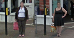
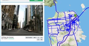
A British woman has been left "flabbergasted" after she was captured on Google Maps Street View standing in the exact same spot nine years apart.
A British woman has been left "flabbergasted" after she was captured on Google Maps Street View standing in the exact same spot nine years apart.

To celebrate Google Street View's 15th birthday, the tech giant has rolled out its historical Street View imagery to mobile after it was previously only available on desktop.
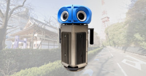
Google Street View is celebrating its 15th birthday by unveiling a brand new compact and lightweight camera system. This new camera weighs less than half of the current Google Street View cameras and is more customizable.
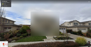
Google Street View cameras have now captured over 170 billion photos from 10 million miles around the globe. But if you're not comfortable with the fact that anyone can "visit" your home digitally, did you know you can request to have it blurred from public view?
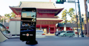
Google Street View was created using an army of iconic camera cars driving up and down all the streets of mapped areas. Starting today, though, anyone with an Android camera can effectively become a Street View car and contribute to the massive trove of explorable location photos.
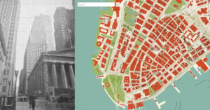
1940s NYC is a new online interactive map created by NYC-based software engineer Julian Boilen. It's like Google Street View, except every photo taken shows New York City between 1939 and 1941.
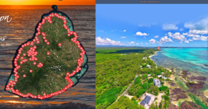
Reuben Pillay is a drone enthusiast living on Mauritius, the island nation 1,200 miles southeast off the African continent. He has spent over a year and a half working single-handedly on a project called ReubsVision -- it's essentially like an aerial Google Street View of the island's entire coastline (and more).
Creative Director Yousuke Ozawa—whose 'Satellite Fonts' project went viral back in 2014—is at it again. In order to keep his sanity during lockdown, he started taking "digital vacations" through Google Maps, and capturing Street View travel photography.
During the COVID-19 pandemic, we have been asked to stay home and shelter in place. This restriction has only increased my desire to explore and road trip. I still need to create and think critically throughout this time, but if I can’t go to new places, how can I make new work?
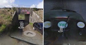
It seems that a Google Street View car in the UK literally ran into a problem when trying to go under a very low overpass in Northern Ireland. Based on the photos it captured and uploaded, it looks like the camera was knocked over onto the roof of the car.

Google has just certified the Insta360 Pro 360-degree 8K camera as the first "Street View Auto Ready" camera, capable of contributing to Street View after being mounted to a car.

Google Street View has just added a tour of the International Space Station. You know... just in case you were taking your next summer holiday there and wanted to plan your sightseeing route through the different modules.
Can machines be trained to create photos that most people would think were shot by a professional human photographer? That's what Google is trying to figure out with a machine learning research project.
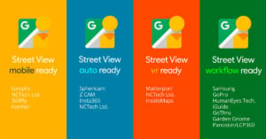
Google announced this week that they are releasing a new certification standard that they are calling “Street View Ready”. This certification will be used for 360° cameras that are able to publish to Street View, and are guaranteed to support the level of quality required for Google’s 360-degree mapping service.
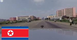
There's no Google Street View in North Korea, but here's the next best thing: Singaporean photographer Aram Pan of DPRK 360 shot an interactive 360-degree video while driving around the streets of the capital city of Pyongyang.
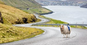
Faroe Islands is an island country halfway between Norway and Iceland. It features some of the world's most beautiful roads, but those routes haven't been traversed by Google's Street View camera cars. So, the country decided to take matters into its own hands by mapping the island with sheep-mounted 360-degree cameras. It's called Sheep View 360.
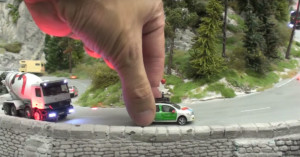
Google's Street View cameras have gone to the ends of the Earth, from under the sea to desolate deserts, in order to document the world in photos. The project is grand, but its latest effort is on a much smaller scale -- literally.
The company just announced Street View for the famous Miniatur Wunderland in Hamburg, Germany, the world's largest model railway. To shoot the images, Google mounted tiny cameras to tiny vehicles (they also had a tiny Street View car look-alike drive around).
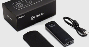
Ricoh has announced the new Theta S, the latest in the company’s lineup of 360-degree cameras. The Theta S features two 12 MP sensors that interpolate with each other to output high-resolution 14.4 MP spherical still images or full 1080p HD video at 30fps. The device is also capable of streaming live video via its built-in USB or HDMI port and is compatible with Google’s Street View technology.
Google set out in 2007 to create an ambitious effort called Street View: a project aimed at providing panoramic views of individual streets around the world. The unique feature, which has since been copied by other mapping services, has, on Android devices, lived within the Google Maps app. Now, however, Street View is breaking free into its own separate application, and it includes a few features for capturing and sharing your own photospheres.

Google Street View is an incredibly powerful tool that has helped to advance mapping in the 21st century. Since the company announced the ability to walk within and view 360-degree photographs of business locations, owners have been taking advantage of the feature to make their establishments stand out. Now, NCTech Imaging has created the iris360, a device that assists in capturing 360-degree images for Street View.

Nasr Bitar took a selfie when a Google Street View car drove behind him last fall, and recently he found a photo of himself taking the selfie on Google Street View.
Google's well-known Street View service is one of several monumental efforts to document the world's travel routes through ground-level photos. These projects generally use fancy camera rigs on cars, backpacks, and even camels to capture their images.
Mapillary is a startup that's trying to do things a little differently. Instead of taking the grunt work of photo-taking upon itself, the service is building a crowdsourced Street View competitor using photos submitted by users.
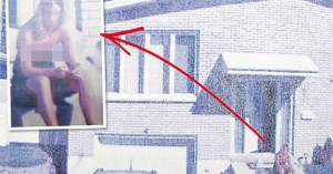
A Canadian judge has ordered Google to pay a Montreal woman for the violation of her privacy after she found an embarrassing photograph of herself on Google Street View. Google's automated cameras had captured the woman sitting on her doorstep, leaning forward with a portion of her cleavage exposed.

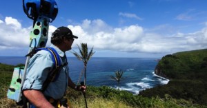
Google has teamed up with the Jane Goodall Institute to bring their Street View Trekker cameras to Gombe National Park in Tanzania, a place made famous by world-famous primatologist Jane Goodall and her research of the local chimpanzees.
Step by step, the Google Street View Trekker camera retraced the steps Goodall took during the 54 years she spent studying the social behavior of chimpanzees.

In Google’s ongoing effort to ‘Street View’ some of the most incredible places on Earth, the company has pushed the limits of the 360-degree genre once again.
This time, Google set out to capture a panoramic view of the Liwa Desert in the United Arab Emirates, by strapping their Street View Trekker Camera onto the back of a willing camel.

Spanish Artist, Mario Santamaria decided to create an interesting self-portrait series, titled The Camera in the Mirror. However, the portraits aren’t of himself, or any human for that matter. They’re of a little piece of engineering from the brains behind Google Street View, retrofitted for Google’s Art Project.
We told you to expect a wave of interesting "then and now" series when Google first integrated the 'time-machine' feature into Street View, and that prophesy is starting to come true.
A couple of weeks ago we showed you GooBing Detroit, a Tumblog that tracked the demise of Detroit in Street View images. And today, Gizmodo published a fascinating look at the rapid pace of gentrification that has transformed several areas of Brooklyn.
Get ready for a whole slew of "Then and Now" photo series featuring Street View images, because Google just turned the entire service into a convenient time machine.
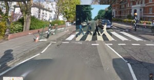
The Guardian has put together an insightful collection of images created by overlaying album covers from times past onto current-day Google Street View locations of the places those album cover photographs were taken.
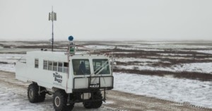
In Google's continuing effort to take over visually document the entire world, they've teamed up with Polar Bears International and taken Street View cameras to Churchill, Manitoba, more commonly referred to as the "Polar Bear capital of the world."

The Google Street View team went amphibious for its latest mission: a 360-degree capture of the canals, streets and piazzas of Venice -- the city many view as the most romantic on Earth Venice.

Few people without PhDs ever set foot inside CERN's (The European Organization for Nuclear Research) lab in Geneva, Switzerland, home of the Large Hadron Collider. And although we have had the opportunity to share some stunning pics of the world's largest particle accelerator before, Google is one-upping us (go figure) by letting you take a virtual stroll with Street View.

What happens when you give a bunch of skaters, some photographers and a light painter free reign to create a Street View tour of a French concert venue/cultural hotspot? We'll give you a hint, it's similar to what a French ski shop did for its virtual tour.

It's obvious that Google is interested in mapping just about everything that is mappable via Street View, but even our future overlords they need some help on occasion. Although the company is willing to send employees with trekker backpacks to many an exotic location, when it comes to taking a virtual tour of local businesses, the search giant hires on "trusted photographers."
One such photographer recently sat down with Tested and told them all about the process of becoming a Google Business Trusted Photographer and taking Street View indoors.
On your own mental list of "most perilous jobs," chances are Google Street View driver doesn't make it very close to the top. But one of Google's own wound up in a strange situation recently when a group of villagers in Thailand put him under citizen's arrest, believing him to be a spy for a government dam project they oppose.
Google has had no issues expanding street view to some pretty amazing places. Thanks in large part to the company's trekker backpacks, we can now visit the Grand Canyon, explore Central Park and check out the view from the world's tallest peaks.
But the company isn't above asking others to help expand the "off-road" street view repertoire, and so Google is announcing plans to loan out those expensive Trekkers to worthy third party organizations.
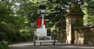
In partnership with Historypin and the Central Park Conservancy, Google has decided to expand its Street View repertoire once again, this time letting out-of-towners experience three of The Big Apple's most historically significant locations: Central Park, The 9/11 Memorial and places affected by Hurricane Sandy.

Hyperlapse photography involves shooting a series of photographs over large distances and then stringing the photos together into a time-lapse video that zooms the viewer through the locations. Creating a real hyperlapse involves quite a bit of work, so the folks over at Teehan+Lax Labs decided to go virtual by turning to Google Street View to source the necessary photos.
The gorgeous hyperlapse video above was created entirely using Google Street View photos, and shows the locations visited by the Street View camera van in a way that's very different from what you see through your browser.

Check out this one-of-a-kind music video for the song "Could Be Me" by the band Gunnar and The Grizzly Boys. The video is titled "Redneck Country Band Ambushes Google Street View Car!," and appears to be a music video shot entirely through the cameras of Google's Street View cars.
Due to the tragic Great East Japan Earthquake and the tsunami and nuclear disaster that it caused, the 21,000 residents of Namie-machi, Fukushima, Japan had to evacuate their homes. Even now, a little over two years later, the residual radiation makes it impossible for those former residents to return to the homes and businesses they were forced to abandon.
Still, many would like to see what has become of their town in the intervening years, and so Google teamed up Namie-machi mayor Tamotsu Baba to make that wish come true. As of yesterday, the displaced residents of Namie-machi (along with the rest of us) can tour the entire nuclear ghost town digitally.